Difference between revisions of "2009-08-17 48 12"
From Geohashing
imported>Tomcat (New page: {{meetup graticule | map=<map lat="48" lon="12" date="2009-08-17" /> | lat=48 | lon=12 | date=2009-08-17 | graticule_name=Landshut, Germany | graticule_link=Landshut, Germany}} == Expediti...) |
imported>Dawidi (a few more pictures and a bit of detail in the text...) |
||
| Line 6: | Line 6: | ||
| graticule_name=Landshut, Germany | | graticule_name=Landshut, Germany | ||
| graticule_link=Landshut, Germany}} | | graticule_link=Landshut, Germany}} | ||
| + | In the forest between Matting and Graßlfing, about 7km south of Regensburg. | ||
| + | |||
== Expedition == | == Expedition == | ||
| − | A short and uneventful expedition in the evening - just as the previous one in this graticule. dawidi, Hans and Tomcat went to Matting by bike where they awaited huirad at the ferry. Together they made it to the hashpoint, took the usual photographs there, cycled back to Regensburg and split off. | + | A short and uneventful expedition in the evening - just as the previous one in this graticule. dawidi, Hans and Tomcat went to Matting by bike where they awaited huirad at the ferry. |
| + | |||
| + | Together they cycled uphill into the forest and found that what had looked like some sort of field in the outdated satellite imagery was in fact an afforestation with very dense trees. Nevertheless, they made it to the hashpoint, took the usual photographs there, coasted downhill through Graßlfing to Unterirading, cycled back to Regensburg and split off. | ||
== Photos == | == Photos == | ||
| − | |||
<gallery> | <gallery> | ||
| − | Image:GH 2009-08-17 48 12 gps.jpg | | + | Image:GH 2009-08-17 48 12 gps.jpg|Coordinates reached. |
| − | Image:GH 2009-08-17 48 12 at the hash.jpg | | + | Image:GH 2009-08-17 48 12 at the hash.jpg|At the hash. |
| + | Image:2009-08-17 48 12 group.jpg|Another group portrait - dawidi, Tomcat, Hans, huirad. | ||
| + | Image:2009-08-17 48 12 tripod.jpg|Treepod win :) | ||
| + | Image:2009-08-17 48 12 aufforstung.jpg|Inside the afforestation | ||
</gallery> | </gallery> | ||
Revision as of 05:34, 19 August 2009
| Mon 17 Aug 2009 in Landshut, Germany: 48.9589686, 12.0248295 geohashing.info google osm bing/os kml crox |
In the forest between Matting and Graßlfing, about 7km south of Regensburg.
Expedition
A short and uneventful expedition in the evening - just as the previous one in this graticule. dawidi, Hans and Tomcat went to Matting by bike where they awaited huirad at the ferry.
Together they cycled uphill into the forest and found that what had looked like some sort of field in the outdated satellite imagery was in fact an afforestation with very dense trees. Nevertheless, they made it to the hashpoint, took the usual photographs there, coasted downhill through Graßlfing to Unterirading, cycled back to Regensburg and split off.
Photos

Coordinates reached.

At the hash.
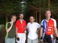
Another group portrait - dawidi, Tomcat, Hans, huirad.

Treepod win :)
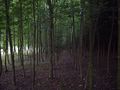
Inside the afforestation


