Difference between revisions of "2009-08-29 52 -0"
imported>Joehardflec (New page: {{subst:Expedition |lat = 52 |lon = -0 |date = 2009-08-29 }}) |
imported>Joehardflec |
||
| Line 1: | Line 1: | ||
| − | |||
<!-- If you did not specify these parameters in the template, please substitute appropriate things for IMAGE, LAT, LON, and DATE (YYYY-MM-DD format) --> | <!-- If you did not specify these parameters in the template, please substitute appropriate things for IMAGE, LAT, LON, and DATE (YYYY-MM-DD format) --> | ||
<!-- | <!-- | ||
| Line 13: | Line 12: | ||
__NOTOC__ | __NOTOC__ | ||
== Location == | == Location == | ||
| − | + | Field between Billesdon Coplow and Houghton. A footpath runs nearby. | |
| − | |||
== Participants == | == Participants == | ||
| − | + | [[User:Joehardflec|Joe Hardman]] | |
| − | + | [[User:Happyhannah|Happyhannah]] +1 | |
| − | |||
| − | |||
== Expedition == | == Expedition == | ||
| + | ===Joe=== | ||
| + | Joe headed in from the Houghton side about 15min before the meetup time, and headed along the footpath to see if it went into the hashpoint field. It didn't. The footpath went along the wrong side of the field boundary. He waited at the stile until 4pm (meetup time), took a photo of the hashpoint from a gate at the edge of the field, and left an 'xkcd' in twigs infront of the gate. He then wandered back along the footpath to the farm track, where he spotted two people with a GPS, and went and said hello. | ||
| + | {{Meet-up | ||
| + | | latitude = 52 | ||
| + | | longitude = -0 | ||
| + | | date = 2009-08-29 | ||
| + | | name = [[User:Joehardflec|Joe Hardman]] | ||
| + | | other = [[User:Happyhannah|Happyhannah]] +1 | ||
| + | | image = image name (optional) | ||
| + | }} | ||
| + | He then decided to continue on, up to the farmhouse, and go for an Ambassador Geohash, and said goodbye to the others. He met a farmer coming down the track, and obtained permission to access the hashpoint itself. | ||
| − | + | {{land geohash | |
| − | == | + | | latitude = 52 |
| − | + | | longitude = -0 | |
| + | | date = 2009-08-29 | ||
| + | | name = [[User:joehardflec|Joe Hardman]] | ||
| + | | image = image name (optional) | ||
| + | }} | ||
| + | {{Ambassador geohash | ||
| + | | latitude = 52 | ||
| + | | longitude = -0 | ||
| + | | date = 2009-08-29 | ||
| + | | granter = Farmer | ||
| + | | name = [[User:joehardflec|Joe Hardman]] | ||
| + | | image = image name (optional) | ||
| + | }} | ||
| + | ===Happyhannah=== | ||
| + | Happyhannah has not yet written up a report. | ||
== Photos == | == Photos == | ||
| − | |||
| − | |||
| − | |||
| − | |||
| − | |||
| − | |||
<gallery perrow="3"> | <gallery perrow="3"> | ||
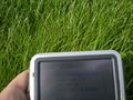
| + | Image:2009-08-29 52 -0 JoeGPS.jpg | The Hashpoint | ||
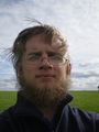
| + | Image:2009-08-29 52 -0 Joe.jpg | Joe | ||
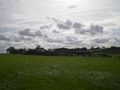
| + | Image:2009-08-29 52 -0 JoeView1.jpg | View from the point | ||
</gallery> | </gallery> | ||
| − | |||
| − | |||
| − | |||
| − | |||
| − | |||
[[Category:Expeditions]] | [[Category:Expeditions]] | ||
| − | |||
[[Category:Expeditions with photos]] | [[Category:Expeditions with photos]] | ||
| + | |||
| + | <!-- and maybe | ||
[[Category:Expeditions with videos]] | [[Category:Expeditions with videos]] | ||
| − | |||
--> | --> | ||
| − | |||
[[Category:Coordinates reached]] | [[Category:Coordinates reached]] | ||
| − | |||
| − | |||
| − | |||
| − | |||
| − | |||
| − | |||
[[Category:Not reached - No public access]] | [[Category:Not reached - No public access]] | ||
| − | |||
| − | |||
| − | |||
Revision as of 18:56, 29 August 2009
| Sat 29 Aug 2009 in 52,-0: 52.6278569, -0.9720826 geohashing.info google osm bing/os kml crox |
Location
Field between Billesdon Coplow and Houghton. A footpath runs nearby.
Participants
Expedition
Joe
Joe headed in from the Houghton side about 15min before the meetup time, and headed along the footpath to see if it went into the hashpoint field. It didn't. The footpath went along the wrong side of the field boundary. He waited at the stile until 4pm (meetup time), took a photo of the hashpoint from a gate at the edge of the field, and left an 'xkcd' in twigs infront of the gate. He then wandered back along the footpath to the farm track, where he spotted two people with a GPS, and went and said hello.
Joe Hardman earned the Meet-up achievement
|
He then decided to continue on, up to the farmhouse, and go for an Ambassador Geohash, and said goodbye to the others. He met a farmer coming down the track, and obtained permission to access the hashpoint itself.
Joe Hardman earned the Land geohash achievement
|
Joe Hardman earned the Ambassador achievement
|
Happyhannah
Happyhannah has not yet written up a report.
Photos
The Hashpoint
Joe
View from the point


