Difference between revisions of "2009-09-09 50 10"
imported>Jiml m (Compact the Photos) |
imported>FippeBot m (Location) |
||
| Line 44: | Line 44: | ||
[[Category:Coordinates reached]] | [[Category:Coordinates reached]] | ||
[[Category:Danatar]] | [[Category:Danatar]] | ||
| + | {{location|DE|BY|SW}} | ||
Latest revision as of 05:43, 8 August 2019
| Wed 9 Sep 2009 in Gotha: 50.0945707, 10.1858268 geohashing.info google osm bing/os kml crox |
Location
Today's location is in a harvested maize field near Poppenhausen-Maibach, not far from Schweinfurt.
Country: Germany; state: Bayern (Bavaria, EU:DE:BY); administrative region: Unterfranken; district: Schweinfurt rural district
Weather (17:30): Sunny, warm, very nice
Expedition
Danatar
On this 9th day of the 9th month in the 9th year of the millenium I did my 9*9th expedition. After more than 9 hours of work I started my car to drive less than 9 kilometres in about 9 minutes (+/- 99 seconds), then I stopped on a track near the hashpoint. About 9*9*sqrt(9) metres of walking and a jump over a small ditch later I stood at the hashpoint and enjoyed the sunshine. On the way back I found a tree with ripe plums and picked a handfull of them.
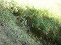
I had to jump over this
GPS

Coordinates reached
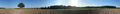
Panorama at the hashpoint
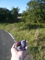
Hashplums! In the background between the trees you can see the hashpoint.


Danatar earned the number of the ʇsɐǝq gratuitous ribbon
|