Difference between revisions of "2009-09-12 48 9"
imported>Ekorren (creating planning page) |
imported>Ekorren (Gallery up) |
||
| Line 13: | Line 13: | ||
[[User:ekorren|ekorren]] | [[User:ekorren|ekorren]] | ||
| − | == Expedition | + | == Expedition == |
| − | Ekorren | + | Ekorren was there at 4 pm. |
== Gallery == | == Gallery == | ||
| + | Once again, I made one more or less random photo every 60 minutes, this time around 25 minutes past the full hour (I started from home at 8:25). An interesting effect is that these pictures make it look like I was in inhabited area almost all the time, while I actually went through open landscape most of the trip. There's a reason to that: Since I tend to detour into each village centre along the way to drop off a bookcrossing book, and you generally are slower in average while passing those, and most breaks are also within settlements, the percentage of ''time'' within settlements is much higher then the percentage of ''distance''. | ||
| − | [[Category: | + | <gallery> |
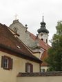
| − | + | Image:2009-09-12_48_9_0925_Pfullingen.jpg|'''9:25 - Pfullingen'''<br>This town has many nicer views. But when it was time to take that photo, I just passed that large and ugly industrial area. | |
| + | Image:2009-09-12_48_9_1025_Rampe.jpg|'''10:25 - 10%.'''<br>Would you like a 20% slope better? | ||
| + | Image:2009-09-12_48_9_Lichtenstein.jpg|A view over the valley to Castle Lichtenstein. | ||
| + | Image:2009-09-12_48_9_1125_Grossengstingen.jpg|'''11:25 - Großengstingen''' | ||
| + | Image:2009-09-12_48_9_Lauterquelle.jpg|Source of the Lauter river which I was about to follow for the next three hours. | ||
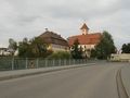
| + | Image:2009-09-12_48_9_1225_BfGomadingen.jpg|'''12:25 - Gomadingen'''<br>No trains here today, anyway. | ||
| + | Image:2009-09-12_48_9_Wasserstetten.jpg|A memorial for a special facility that once was here. Guess what this guy is doing? | ||
| + | Image:2009-09-12_48_9_Wacholderheide.jpg|One typical Alb landscape is the ''juniper heath''. | ||
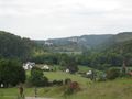
| + | Image:2009-09-12_48_9_1325_Lautertal.jpg|'''13:25 - Lauter valley''' | ||
| + | Image:2009-09-12_48_9_Hundersingen.jpg|Castle ruins generally aren't of short supply here. | ||
| + | Image:2009-09-12_48_9_Bichishausen_Kanus.jpg|Canoos! Doesn't seem they have much business today. Anyway, every potential waterhash you could reach with them you can also reach by wading. | ||
| + | Image:2009-09-12_48_9_Felsen.jpg|Rocks aren't of short supply, either. | ||
| + | Image:2009-09-12_48_9_1425_Niedergundelfingen.1.jpg|Castle Niedergundelfingen was private property, unfortunately. | ||
| + | Image:2009-09-12_48_9_Gundelfingen_Ziege.jpg|Meeeh! | ||
| + | Image:2009-09-12_48_9_Indelhausen.jpg|Hash village | ||
| + | Image:2009-09-12_48_9_1525_Indelhausen.jpg|'''15:25 - Indelhausen'''<br>A view back along the Lauter valley | ||
| + | Image:2009-09-12_48_9_ViewOnHash_1.jpg|The hash must be down there. | ||
| + | Image:2009-09-12_48_9_ViewOnHash_2.jpg|Over there, actually. | ||
| + | Image:2009-09-12_48_9_GPS.jpg|Coordinates reached, now waiting for 16:00. | ||
| + | Image:2009-09-12_48_9_ViewFromHash.jpg|View from hash | ||
| + | Image:2009-09-12_48_9_Marker.jpg|Marker placed at track. | ||
| + | Image:2009-09-12_48_9_Energy.jpg|Energy lines | ||
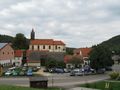
| + | Image:2009-09-12_48_9_1625_Hayingen.jpg|'''16:25 - Hayingen''' | ||
| + | Image:2009-09-12_48_9_Hayingen_Kappenturm.jpg|Rumour says that, when the town was under attack about 300 years ago, they didn't find the bolt and thus were unable to actually close this gate. They lost. | ||
| + | Image:2009-09-12_48_9_Wimsener_Hoehle.jpg|Wimsen cave, a #1 tourist destination. | ||
| + | Image:2009-09-12_48_9_ZwiefaltenerAach.jpg|Arbitrary landscape impression | ||
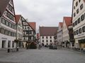
| + | Image:2009-09-12_48_9_1725_Zwiefalten_Peterstor.jpg|'''17:25 - Zwiefalten''' | ||
| + | Image:2009-09-12_48_9_Zwiefalten_2.jpg | ||
| + | Image:2009-09-12_48_9_Donautalweg_Bruecke.jpg|This part of the Donau valley trail is probably a major bottleneck on warmer days. | ||
| + | Image:2009-09-12_48_9_1825_Zell.jpg|'''18:25 - Zell''' | ||
| + | Image:2009-09-12_48_9_1925_Riedlingen.jpg|'''19:25 - Riedlingen''' | ||
| + | </gallery> | ||
| + | |||
| + | [[Category:Expeditions]] | ||
[[Category:Expeditions with photos]] | [[Category:Expeditions with photos]] | ||
| − | + | [[Category:Coordinates reached]] | |
| − | [[Category:Coordinates | ||
| − | |||
Revision as of 11:41, 13 September 2009
| Wed 26 Aug 2009 in 48,9: 48.5313907, 9.3749877 geohashing.info google osm bing/os kml crox |
Contents
Location
A field north of Hayingen.
Participants
Expedition
Ekorren was there at 4 pm.
Gallery
Once again, I made one more or less random photo every 60 minutes, this time around 25 minutes past the full hour (I started from home at 8:25). An interesting effect is that these pictures make it look like I was in inhabited area almost all the time, while I actually went through open landscape most of the trip. There's a reason to that: Since I tend to detour into each village centre along the way to drop off a bookcrossing book, and you generally are slower in average while passing those, and most breaks are also within settlements, the percentage of time within settlements is much higher then the percentage of distance.
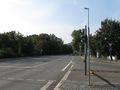
9:25 - Pfullingen
This town has many nicer views. But when it was time to take that photo, I just passed that large and ugly industrial area.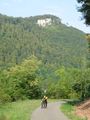
10:25 - 10%.
Would you like a 20% slope better?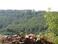
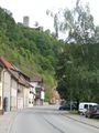
A view over the valley to Castle Lichtenstein.
11:25 - Großengstingen
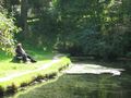
Source of the Lauter river which I was about to follow for the next three hours.
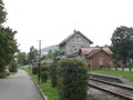
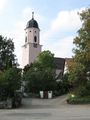
12:25 - Gomadingen
No trains here today, anyway.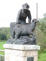
A memorial for a special facility that once was here. Guess what this guy is doing?
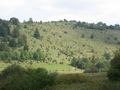
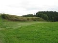
One typical Alb landscape is the juniper heath.

13:25 - Lauter valley
Castle ruins generally aren't of short supply here.
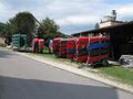
Canoos! Doesn't seem they have much business today. Anyway, every potential waterhash you could reach with them you can also reach by wading.
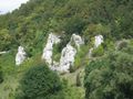
Rocks aren't of short supply, either.
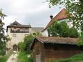
Castle Niedergundelfingen was private property, unfortunately.
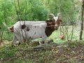
Meeeh!
Hash village
15:25 - Indelhausen
A view back along the Lauter valley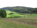
The hash must be down there.
Over there, actually.
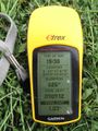
Coordinates reached, now waiting for 16:00.
View from hash

Marker placed at track.

Energy lines
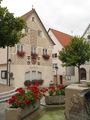
16:25 - Hayingen
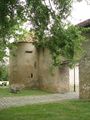
Rumour says that, when the town was under attack about 300 years ago, they didn't find the bolt and thus were unable to actually close this gate. They lost.
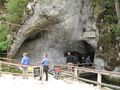
Wimsen cave, a #1 tourist destination.
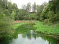
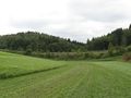
Arbitrary landscape impression
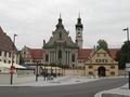
17:25 - Zwiefalten
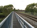
This part of the Donau valley trail is probably a major bottleneck on warmer days.
18:25 - Zell
19:25 - Riedlingen


