Difference between revisions of "2009-09-28 48 10"
imported>Ekorren (Tracklog) |
imported>Ekorren (→Gallery: 32 pictures) |
||
| Line 21: | Line 21: | ||
== Gallery == | == Gallery == | ||
| − | + | Again with hourly more or less random photos. | |
<gallery> | <gallery> | ||
| + | Image:2009-09-28_48_9_Ehrenbachtal.jpg|Early morning in the valley | ||
| + | Image:2009-09-28_48_9_Haerten.jpg|Early morning in the hills | ||
| + | Image:2009-09-28_48_10_0800_Breakfast.jpg|'''8:00'''<br>Breakfast at a bakery at Ohmenhausen | ||
| + | Image:2009-09-28_48_10_Reutlingen_FeH55.jpg|Ancient type of phone box. Possibly the last one of its kind in use outside of a museum! | ||
| + | Image:2009-09-28_48_10_0900_RT_Georgenberg.jpg|'''9:00'''<br>Trying to get around this mountain. Half-failed. | ||
| + | Image:2009-09-28_48_10_Schild_Goellesbergsteige.jpg|This way up. | ||
| + | Image:2009-09-28_48_10_1000_Goellesbergsteige.jpg|'''10:00'''<br>Climbing up the ''Albtrauf'' on a minor road | ||
| + | Image:2009-09-28_48_10_1100_LonsingerTal.jpg|'''11:00'''<br>Taking the lower route | ||
| + | Image:2009-09-28_48_10_1200_Muensingen.jpg|'''12:00'''<br>At Münsingen. This train only goes to the next two villages. | ||
| + | Image:2009-09-28_48_10_Bahntrasse_Schandental.jpg|Rural railway track - One train on schooldays. | ||
| + | Image:2009-09-28_48_10_1300_Schandental.jpg|'''13:00'''<br>Down the Schandental valley | ||
| + | Image:2009-09-28_48_10_1400_Schelklingen.jpg|'''14:00'''<br>Between Schelklingen and Blaubeuren | ||
| + | Image:2009-09-28_48_10_Spitzer_Stein.jpg|The Space Shuttle was not an american invention. It was brought by aliens millions of years ago. | ||
| + | Image:2009-09-28_48_10_1500_Blaubeuren.jpg|'''15:00'''<br>Blaubeuren | ||
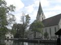
| + | Image:2009-09-28_48_10_Blaubeuren_Kirchturmspitze.jpg|Blaubeuren monastery church | ||
| + | Image:2009-09-28_48_10_Blaubeuren_Kirche.jpg | ||
| + | Image:2009-09-28_48_10_Blaubeuren_Blautopf_Gebaeude.jpg | ||
| + | Image:2009-09-28_48_10_Blaubeuren_Blautopf.jpg|"Blue pot" | ||
| + | Image:2009-09-28_48_10_Blaubeuren_Lau.jpg|The ''Schöne Lau'' | ||
| + | Image:2009-09-28_48_10_Blautal.jpg|River Blue | ||
| + | Image:2009-09-28_48_10_1600_Blautal.jpg|'''16:00'''<br>Random rock impression | ||
| + | Image:2009-09-28_48_10_1700_UlmerMuenster.jpg|'''17:00'''<br>View from Neu-Ulm over the Danube on Ulm Cathedral | ||
| + | Image:2009-09-28_48_10_Donaubruecke.jpg|Along the Danube | ||
| + | Image:2009-09-28_48_10_1800_Donau_Kraftwerk.jpg|'''18:00'''<br>Further along the Danube | ||
| + | Image:2009-09-28_48_10_Schild_Weissingen_Schulbus.jpg|''Attention! Due to road construction you will meet the school bus on this track.'' | ||
| + | Image:2009-09-28_48_10_Hashpoint.jpg|The hashpoint | ||
| + | Image:2009-09-28_48_10_GPS.jpg|Coordinates reached | ||
| + | Image:2009-09-28_48_10_Sunset_at_hash.jpg|View from hash | ||
| + | Image:2009-09-28_48_10_Langenau_Bfschild.jpg|Back home from the station of Langenau... | ||
| + | Image:2009-09-28_48_10_Vandals.jpg|... which on the other platform was renamed. | ||
| + | Image:2009-09-28_48_10_Run.jpg|'''Run!!!''' | ||
| + | Image:2009-09-28_48_10_odometer.jpg|Trip odometre total for the day | ||
</gallery> | </gallery> | ||
Revision as of 18:25, 29 September 2009
| Mon 28 Sep 2009 in 48,10: 48.4664166, 10.1743325 geohashing.info google osm bing/os kml crox |
Location
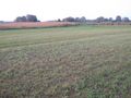
A meadow at Langenau (Württemberg), although closer to Leipheim-Riedheim. Very close to the bavarian border.
Participants
Expedition
to be done
This was part 2 of a bicycle double hash with a total length of 156.28 km. Started at 7:20, arrived at this hash at 18:50.
Gallery
Again with hourly more or less random photos.
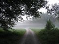
Early morning in the valley
Early morning in the hills
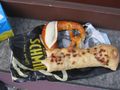
8:00
Breakfast at a bakery at Ohmenhausen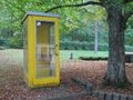
Ancient type of phone box. Possibly the last one of its kind in use outside of a museum!
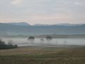
9:00
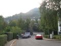
Trying to get around this mountain. Half-failed.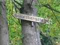
This way up.
10:00
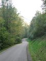
Climbing up the Albtrauf on a minor road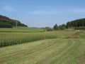
11:00
Taking the lower route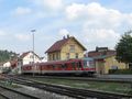
12:00
At Münsingen. This train only goes to the next two villages.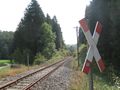
Rural railway track - One train on schooldays.

13:00
Down the Schandental valley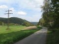
14:00
Between Schelklingen and Blaubeuren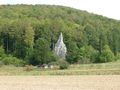
The Space Shuttle was not an american invention. It was brought by aliens millions of years ago.

15:00
Blaubeuren
Blaubeuren monastery church
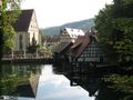

"Blue pot"
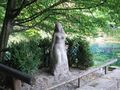
The Schöne Lau

River Blue

16:00
Random rock impression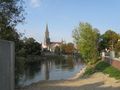
17:00
View from Neu-Ulm over the Danube on Ulm Cathedral
Along the Danube
18:00
Further along the Danube
Attention! Due to road construction you will meet the school bus on this track.
The hashpoint

Coordinates reached

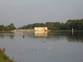
View from hash
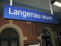
Back home from the station of Langenau...

... which on the other platform was renamed.

Run!!!
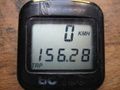
Trip odometre total for the day


Tracklog
...is here.