Difference between revisions of "2009-10-07 60 22"
From Geohashing
imported>Jiml m (Result category isn't working for some reason) |
imported>FippeBot m (Location) |
||
| (One intermediate revision by one other user not shown) | |||
| Line 19: | Line 19: | ||
Image:2009_10_07_60_22_control.jpg|Control point of Turkurastit. | Image:2009_10_07_60_22_control.jpg|Control point of Turkurastit. | ||
Image:2009_10_07_60_22_kilpertti.jpg|Kilpertti in hash point.. | Image:2009_10_07_60_22_kilpertti.jpg|Kilpertti in hash point.. | ||
| − | /gallery> | + | </gallery> |
[[Category:Expeditions with photos]] | [[Category:Expeditions with photos]] | ||
[[Category:Expeditions]] | [[Category:Expeditions]] | ||
[[Category:Coordinates reached]] | [[Category:Coordinates reached]] | ||
| + | {{location|FI|19}} | ||
Latest revision as of 06:12, 8 August 2019
| Wed 7 Oct 2009 in 60,22: 60.4156129, 22.2083447 geohashing.info google osm bing/os kml crox |
Location
This point is in island of Hirvensalo in front of the city of Turku, Finland. This point was found by Kilpertti.
Expedition
This hash point happened to fall near three of my geocaches. It was in the wood near a nature trail. There was going a fitness orienteering event called Turkurastit. One of their controlpoints was behind a corner of rock just 20 meters from this hash point. It was funny to look people seeking their point.
Photos
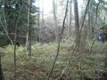
Not really a good viewpoint. On the right there is one orienteerer going to the control point.

Control point of Turkurastit.

Kilpertti in hash point..


