Difference between revisions of "2009-10-15 34 -106"
imported>Redaragorn |
imported>Redaragorn |
||
| Line 21: | Line 21: | ||
== Expedition == | == Expedition == | ||
It was simple enough to get through Belen and over the river, but I wasn't super sure where to turn off to get there. I trusted the GPS directions and they got me pretty close, but I could tell when I got within a mile or two that some of the "roads" it thought were there really weren't. Or at least weren't much of a road. The last mile was a very bumpy track with a medium-fun arroyo crossing. We got within a few hundred feet and got out to walk over to the hash point. The spot wasn't much to look at, but at least it was a beautiful day! The drive out was uneventful and we were on our way to our next adventure...the [[2009-10-15 33 -107|ToC]] hash! | It was simple enough to get through Belen and over the river, but I wasn't super sure where to turn off to get there. I trusted the GPS directions and they got me pretty close, but I could tell when I got within a mile or two that some of the "roads" it thought were there really weren't. Or at least weren't much of a road. The last mile was a very bumpy track with a medium-fun arroyo crossing. We got within a few hundred feet and got out to walk over to the hash point. The spot wasn't much to look at, but at least it was a beautiful day! The drive out was uneventful and we were on our way to our next adventure...the [[2009-10-15 33 -107|ToC]] hash! | ||
| + | |||
| + | == Track == | ||
| + | |||
| + | Check out the GPS track [http://www.trailguru.com/wiki/index.php/Track:9T0U?units=imperial here]. | ||
== Pictures == | == Pictures == | ||
Revision as of 05:00, 17 October 2009
| Thu 15 Oct 2009 in 34,-106: 34.5367191, -106.5148327 geohashing.info google osm bing/os kml crox |
Location
Off a "road" near the southern end of the Manzano Mountains on Tierra Grande land.
Participants
- Redaragorn and 3 yr old son
Plans
We were headed south to go camping anyway, and I saw that this one wasn't so far off the highway as to be unreasonable. At least I thought it would be relatively quick and easy. I knew it would be dirt roads to get out there and back, but I decided to try it anyway.
Expedition
It was simple enough to get through Belen and over the river, but I wasn't super sure where to turn off to get there. I trusted the GPS directions and they got me pretty close, but I could tell when I got within a mile or two that some of the "roads" it thought were there really weren't. Or at least weren't much of a road. The last mile was a very bumpy track with a medium-fun arroyo crossing. We got within a few hundred feet and got out to walk over to the hash point. The spot wasn't much to look at, but at least it was a beautiful day! The drive out was uneventful and we were on our way to our next adventure...the ToC hash!
Track
Check out the GPS track here.
Pictures
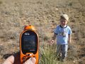
GPS coordinates.

Goofy grin.

