Difference between revisions of "2009-10-15 33 -107"
imported>Redaragorn (New page: {{meetup graticule | map=<map lat="33" lon="-107" date="2009-10-15" /> | lat=33 | lon=-107 | date=2009-10-15 }} == Location == On a ridge southwest of the San Mateo Mountains, approache...) |
imported>Redaragorn |
||
| Line 21: | Line 21: | ||
== Expedition == | == Expedition == | ||
We made a side trip to the [[2009-10-15 34 -106|Los Lunas]] hash on the way down, but after that made straight to the hinterlands. The approach to the 4WD roads was straightforward enough, and I was only slightly put off when I saw that I still had 15 mi to go once I got onto the really bumpy road. I had plenty of day ahead of me still, and the boy was in good spirits. I got a little more worried when I saw how slow I was going to have to go to make it through safely...and realized how long this was going to take. I had to go down in and back up out of canyon after canyon, it seemed. The views of the San Mateos were neat, and the weather was incredible, but it was taking longer than I expected. When we finally bumped up the last ridge and came to the hairpin turn where we pulled out to amble the quarter mile to the hash, I was pretty glad. We went down the hill to celebrate at the hash, then got back into the car, determined NOT to go back the way we came in. About a mile further down the road, we found a "Road Closed" sign--facing the opposite direction. Apparently, the road I just drove across was closed for some reason. Go figure. | We made a side trip to the [[2009-10-15 34 -106|Los Lunas]] hash on the way down, but after that made straight to the hinterlands. The approach to the 4WD roads was straightforward enough, and I was only slightly put off when I saw that I still had 15 mi to go once I got onto the really bumpy road. I had plenty of day ahead of me still, and the boy was in good spirits. I got a little more worried when I saw how slow I was going to have to go to make it through safely...and realized how long this was going to take. I had to go down in and back up out of canyon after canyon, it seemed. The views of the San Mateos were neat, and the weather was incredible, but it was taking longer than I expected. When we finally bumped up the last ridge and came to the hairpin turn where we pulled out to amble the quarter mile to the hash, I was pretty glad. We went down the hill to celebrate at the hash, then got back into the car, determined NOT to go back the way we came in. About a mile further down the road, we found a "Road Closed" sign--facing the opposite direction. Apparently, the road I just drove across was closed for some reason. Go figure. | ||
| + | |||
| + | == Track == | ||
| + | |||
| + | Check out the GPS track [http://www.trailguru.com/wiki/index.php/Track:9T0Q?units=imperial here]. | ||
== Pictures == | == Pictures == | ||
Revision as of 04:28, 17 October 2009
| Thu 15 Oct 2009 in 33,-107: 33.5367191, -107.5148327 geohashing.info google osm bing/os kml crox |
Location
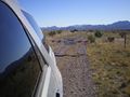
On a ridge southwest of the San Mateo Mountains, approached by a drive on 4WD roads.
Participants
- Redaragorn and 3 yr old son
Plans
We'd been planning a camping trip to the Magdalena or San Mateo mountains, and when I saw that the hash was on Cibola National Forest land close to the mountains I knew just where we were going to head.
Expedition
We made a side trip to the Los Lunas hash on the way down, but after that made straight to the hinterlands. The approach to the 4WD roads was straightforward enough, and I was only slightly put off when I saw that I still had 15 mi to go once I got onto the really bumpy road. I had plenty of day ahead of me still, and the boy was in good spirits. I got a little more worried when I saw how slow I was going to have to go to make it through safely...and realized how long this was going to take. I had to go down in and back up out of canyon after canyon, it seemed. The views of the San Mateos were neat, and the weather was incredible, but it was taking longer than I expected. When we finally bumped up the last ridge and came to the hairpin turn where we pulled out to amble the quarter mile to the hash, I was pretty glad. We went down the hill to celebrate at the hash, then got back into the car, determined NOT to go back the way we came in. About a mile further down the road, we found a "Road Closed" sign--facing the opposite direction. Apparently, the road I just drove across was closed for some reason. Go figure.
Track
Check out the GPS track here.
Pictures
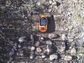
GPS coordinates.
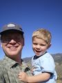
Goofy grins.
Goofy grin.


Achievements
Redaragorn earned the Multihash Achievement
|