Difference between revisions of "2009-10-30 39 -105"
imported>Cmanb (New page: {{meetup graticule | lat=39 | lon=-105 | date=2009-10-30 | graticule_name=SW Denver | graticule_link=Denver, Colorado}} == Location == A driveway in residential Wheat Ridge, at approxima...) |
imported>Cmanb (Updated from "planning" to "achieved") |
||
| Line 14: | Line 14: | ||
[[User:Cmanb | chrisman]] | [[User:Cmanb | chrisman]] | ||
| − | == | + | == Expedition == |
| − | + | Coordinates reached! | |
| − | [[Category: | + | A short retelling. Follow along with the markers at [http://www.mapmyride.com/edit_route?r=497125699792728693 mapmyride] |
| + | |||
| + | 0.00 miles - Begin at Benedict Fountain Park. | ||
| + | |||
| + | 0.84 miles - Loop around the state capitol while continuing south. So pretty all lit up at night! | ||
| + | |||
| + | 2.65 miles - Reach the east side of the 8th Avenue foot bridge. It's almost exactly 0.5 miles, and was completely flooded. The road was fine and dry, separated by a median. But the ice slush was ankle deep most of the way. By the time I got back home, my feet were frigid. | ||
| + | |||
| + | 5.42 miles - Pedaling along a pretty little creek trail, when BOOM! Dead end into a "TRAIL CLOSED" barricade. I might have compromised my Tron achievement here, but I carefully turned around and continued on the other side of the path back out to the street, where I turned up and continued down a side street. | ||
| + | |||
| + | 6.50 miles - Hash site. Google Maps and Google Earth agreed that the hash was basically on the front of this house, by the left windows. Upon arriving, I became uncomfortably aware that I was a Big Dude on a bicycle lurking outside somebody's house after dark. I did not linger. Nor did I come close to walking up to the house and touching the window. I decided that if I was a snowball throw's length away, then I was close enough. I hastily made a pitiful little snowman, left the marker by the mailbox, and left. In my rush, I forgot to get a picture of me at the site! | ||
| + | |||
| + | 8.50 miles - Brief glimpse of Sloans Lake. Pretty. | ||
| + | |||
| + | 10.57 miles - Fox! A big silver fox! Crossed its path as I was leaving the street just past the Aquarium and getting on the South Platte River trail. It was skittering away or acting especially frightened, so I stopped to try to get a picture. I said hello to it in a friendly type manner, in answer to which it turned around and started trotting towards me. This frightened me, so I abandoned the attempt at taking a picture and instead pedaled quickly away. | ||
| + | |||
| + | 11.22 miles - Skate park. Every time I've ever passed the park before now, it had been full of skaters. This time it was empty! I rolled around here for a little while before continuing. | ||
| + | |||
| + | 11.88 miles - Coors Field. No Rockies game tonight, so no extra traffic to deal with. | ||
| + | |||
| + | 12.79 miles - End at Benedict Fountain Park. Good trip! | ||
| + | |||
| + | <gallery caption="Pictures" widths="200px" heights="200px" perrow="3"> | ||
| + | Image:2009.10.30.39.-105.noBatteries.jpg|My "no batteries" GPS. | ||
| + | Image:2009.10.30.39.-105.slushOfDoom.jpg|Ankle deep ice slush. This sucked hard. By the end of the ride my feet were frozen. | ||
| + | Image:2009.10.30.39.-105.trainYard.jpg|Night time. In the switching yard. | ||
| + | Image:2009.10.30.39.-105.roundhouse.jpg|Roundhouse at the trainyard. | ||
| + | Image:2009.10.30.39.-105.trailClosure.jpg|Detour! | ||
| + | Image:2009.10.30.39.-105.hashsite.jpg|The hash is on the house. Left window. Where the lights are on. | ||
| + | Image:2009.10.30.39.-105.marker.PNG|Marker left at the site. | ||
| + | Image:2009.10.30.39.-105.snowman.jpg|SNOWMAN. Kinda. Eh. | ||
| + | Image:2009.10.30.39.-105.confluence.jpg|Confluence of two rivers. Crossed paths with a silver fox just south of here! | ||
| + | Image:2009.10.30.39.-105.skatePark.jpg|Skate park! I did some MAAAAAD tricks no I didn't just kidding. | ||
| + | </gallery> | ||
| + | |||
| + | |||
| + | |||
| + | [[Category:Expeditions]] | ||
| + | [[Category:Expeditions with photos]] | ||
| + | [[Category:Coordinates reached]] | ||
| + | [[Category:Land geohash achievement]] | ||
| + | |||
| + | {{Tron | ||
| + | | latitude = 39 | ||
| + | | longitude = -105 | ||
| + | | date = 2009-10-30 | ||
| + | | tracklog = http://www.mapmyride.com/edit_route?r=497125699792728693 | ||
| + | | possessive = his | ||
| + | | name = Chrisman | ||
| + | }} | ||
| + | {{land geohash | ||
| + | |||
| + | | latitude = 39 | ||
| + | | longitude = -105 | ||
| + | | date = 2009-10-30 | ||
| + | | name = Chrisman | ||
| + | }} | ||
| + | {{Bicycle geohash | ||
| + | |||
| + | | latitude = 39 | ||
| + | | longitude = -105 | ||
| + | | date = 2009-10-30 | ||
| + | | name = Chrisman | ||
| + | | distance = 12.79 mi | ||
| + | }} | ||
| + | {{snowman geohash | ||
| + | |||
| + | | latitude = 39 | ||
| + | | longitude = -105 | ||
| + | | date = 2009-10-30 | ||
| + | | name = Chrisman | ||
| + | }} | ||
| + | {{No_batteries_geohash | ||
| + | |||
| + | | latitude = 39 | ||
| + | | longitude = -105 | ||
| + | | date = 2009-10-30 | ||
| + | | name = Chrisman | ||
| + | }} | ||
Revision as of 16:54, 31 October 2009
| Fri 30 Oct 2009 in SW Denver: 39.7317265, -105.0612421 geohashing.info google osm bing/os kml crox |
Location
A driveway in residential Wheat Ridge, at approximately 920 Gray Street.
Participants
Expedition
Coordinates reached!
A short retelling. Follow along with the markers at mapmyride
0.00 miles - Begin at Benedict Fountain Park.
0.84 miles - Loop around the state capitol while continuing south. So pretty all lit up at night!
2.65 miles - Reach the east side of the 8th Avenue foot bridge. It's almost exactly 0.5 miles, and was completely flooded. The road was fine and dry, separated by a median. But the ice slush was ankle deep most of the way. By the time I got back home, my feet were frigid.
5.42 miles - Pedaling along a pretty little creek trail, when BOOM! Dead end into a "TRAIL CLOSED" barricade. I might have compromised my Tron achievement here, but I carefully turned around and continued on the other side of the path back out to the street, where I turned up and continued down a side street.
6.50 miles - Hash site. Google Maps and Google Earth agreed that the hash was basically on the front of this house, by the left windows. Upon arriving, I became uncomfortably aware that I was a Big Dude on a bicycle lurking outside somebody's house after dark. I did not linger. Nor did I come close to walking up to the house and touching the window. I decided that if I was a snowball throw's length away, then I was close enough. I hastily made a pitiful little snowman, left the marker by the mailbox, and left. In my rush, I forgot to get a picture of me at the site!
8.50 miles - Brief glimpse of Sloans Lake. Pretty.
10.57 miles - Fox! A big silver fox! Crossed its path as I was leaving the street just past the Aquarium and getting on the South Platte River trail. It was skittering away or acting especially frightened, so I stopped to try to get a picture. I said hello to it in a friendly type manner, in answer to which it turned around and started trotting towards me. This frightened me, so I abandoned the attempt at taking a picture and instead pedaled quickly away.
11.22 miles - Skate park. Every time I've ever passed the park before now, it had been full of skaters. This time it was empty! I rolled around here for a little while before continuing.
11.88 miles - Coors Field. No Rockies game tonight, so no extra traffic to deal with.
12.79 miles - End at Benedict Fountain Park. Good trip!
- Pictures
My "no batteries" GPS.
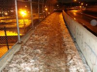
Ankle deep ice slush. This sucked hard. By the end of the ride my feet were frozen.

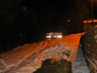
Night time. In the switching yard.
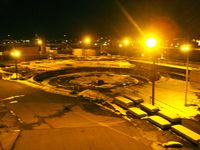
Roundhouse at the trainyard.
Detour!
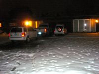
The hash is on the house. Left window. Where the lights are on.

Marker left at the site.
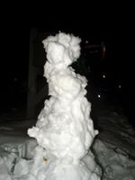
SNOWMAN. Kinda. Eh.
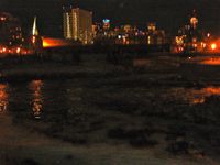
Confluence of two rivers. Crossed paths with a silver fox just south of here!
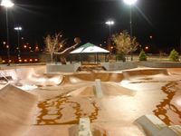
Skate park! I did some MAAAAAD tricks no I didn't just kidding.


Chrisman earned the Tron achievement
|
Chrisman earned the Land geohash achievement
|
Chrisman earned the Bicycle geohash achievement
|
Chrisman earned the Snowman Geohash Achievement
|
Chrisman earned the No Batteries Geohash Achievement
|