Difference between revisions of "2009-11-21 36 -107"
From Geohashing
imported>Redaragorn (New page: {{meetup graticule | map=<map lat="36" lon="-107" date="2009-11-21" /> | lat=36 | lon=-107 | date=2009-11-21 }} == Location == A broad, shallow wash a few miles north of the [http://www...) |
(No difference)
|
Revision as of 05:16, 22 November 2009
| Sat 21 Nov 2009 in 36,-107: 36.1163646, -107.8877227 geohashing.info google osm bing/os kml crox |
Location
A broad, shallow wash a few miles north of the Chaco Culture National Historical Park.
Participants
- Redaragorn and 3 yr old son
Plans
I had a lot going on today again, but I wanted to get out and catch the Bloomfield hash to complete my Minesweeper achievement. I figured if we got off plenty early, we'd be back in time to get all the errands run. Let's hope it works...
Expedition
Track
The GPS track can be found here.
Pictures
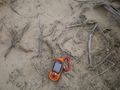
Blurry GPS coordinates.
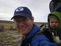
The boy and I, wearing our grins.
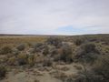
The boy on the road on our way back to the car.


