Difference between revisions of "2009-11-27 37 -122"
From Geohashing
imported>Rs |
imported>Rs (finish adding images, fix user links, mark post as "with photos") |
||
| Line 45: | Line 45: | ||
[[Category:Expeditions]] | [[Category:Expeditions]] | ||
| − | |||
[[Category:Expeditions with photos]] | [[Category:Expeditions with photos]] | ||
| − | |||
| − | |||
| − | |||
[[Category:Coordinates reached]] | [[Category:Coordinates reached]] | ||
| Line 61: | Line 57: | ||
| longitude = -122 | | longitude = -122 | ||
| date = 2009-11-27 | | date = 2009-11-27 | ||
| − | | name = Rs | + | | name = [[User:Rs|Richard Soderberg]] |
| + | | image = 2009-11-27 37 -122 Success.jpg | ||
}} | }} | ||
{{drag-along | {{drag-along | ||
| Line 68: | Line 65: | ||
| longitude = -122 | | longitude = -122 | ||
| date = 2009-11-27 | | date = 2009-11-27 | ||
| − | | partner = ericabiz | + | | partner = [http://www.erica.biz/ ericabiz] |
| − | | name = Rs | + | | name = [[User:Rs|Richard Soderberg]] |
| + | | image = 2009-11-27 37 -122 Dragalong.jpg | ||
}} | }} | ||
Revision as of 21:31, 29 November 2009
| Fri 27 Nov 2009 in 37,-122: 37.9506115, -122.0113219 geohashing.info google osm bing/os kml crox |
Location
Lime Ridge Regional Open Space, in Concord.
Participants
Plans
Hey, it's a mile from our hotel. Let's go!
Expedition
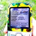
We drove to the road nearest the point and found a coyote warning! There were no coyotes, so we forged ahead for 500 feet in a field of short grass. After chasing a flock of birds I took steps of 0.1 until I found the spot.
Tracklog
Photos
Results
We made it! Yay! First geohash for both of us.
Richard Soderberg earned the Land geohash achievement
|
Richard Soderberg earned the Drag-along achievement
|


