Difference between revisions of "2009-11-27 37 -122"
From Geohashing
imported>Rs (i took some pictures) |
imported>FippeBot m (Location) |
||
| (3 intermediate revisions by one other user not shown) | |||
| Line 13: | Line 13: | ||
== Location == | == Location == | ||
| − | Lime Ridge | + | Lime Ridge Open Space, in Concord. |
== Participants == | == Participants == | ||
| Line 36: | Line 36: | ||
[http://www.flickr.com/photos/rsoderberg/tags/2009112737122/ More photos at Flickr] | [http://www.flickr.com/photos/rsoderberg/tags/2009112737122/ More photos at Flickr] | ||
| − | |||
| − | |||
| − | |||
| − | |||
| − | |||
<gallery perrow="4"> | <gallery perrow="4"> | ||
| − | + | Image:2009-11-27 37 -122 Dragalong.jpg | Erica and I. | |
| + | Image:2009-11-27 37 -122 Hilltop.jpg | Up the hill. | ||
| + | Image:2009-11-27 37 -122 Sign.jpg | You are here. | ||
| + | Image:2009-11-27 37 -122 Success.jpg | We made it! | ||
</gallery> | </gallery> | ||
| − | |||
[[Category:Expeditions]] | [[Category:Expeditions]] | ||
| − | |||
[[Category:Expeditions with photos]] | [[Category:Expeditions with photos]] | ||
| − | |||
| − | |||
| − | |||
[[Category:Coordinates reached]] | [[Category:Coordinates reached]] | ||
| Line 64: | Line 57: | ||
| longitude = -122 | | longitude = -122 | ||
| date = 2009-11-27 | | date = 2009-11-27 | ||
| − | | name = Rs | + | | name = [[User:Rs|Richard Soderberg]] |
| + | | image = 2009-11-27 37 -122 Success.jpg | ||
}} | }} | ||
{{drag-along | {{drag-along | ||
| Line 71: | Line 65: | ||
| longitude = -122 | | longitude = -122 | ||
| date = 2009-11-27 | | date = 2009-11-27 | ||
| − | | partner = ericabiz | + | | partner = [http://www.erica.biz/ ericabiz] |
| − | | name = Rs | + | | name = [[User:Rs|Richard Soderberg]] |
| + | | image = 2009-11-27 37 -122 Dragalong.jpg | ||
}} | }} | ||
| + | {{location|US|CA|CN}} | ||
Latest revision as of 06:56, 8 August 2019
| Fri 27 Nov 2009 in 37,-122: 37.9506115, -122.0113219 geohashing.info google osm bing/os kml crox |
Location
Lime Ridge Open Space, in Concord.
Participants
Plans
Hey, it's a mile from our hotel. Let's go!
Expedition
We drove to the road nearest the point and found a coyote warning! There were no coyotes, so we forged ahead for 500 feet in a field of short grass. After chasing a flock of birds I took steps of 0.1 until I found the spot.
Tracklog
Photos
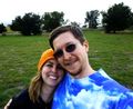
Erica and I.
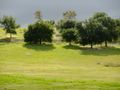
Up the hill.
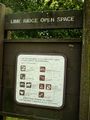
You are here.
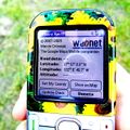
We made it!


Results
We made it! Yay! First geohash for both of us.
Richard Soderberg earned the Land geohash achievement
|
Richard Soderberg earned the Drag-along achievement
|