Difference between revisions of "2009-11-27 47 -122"
imported>Michael5000 (New page: {{subst:Expedition |lat = latitude of graticule |lon = longitude of graticule |date = date of expedition, in YYYY-MM-DD format }}) |
imported>FippeBot m (Location) |
||
| (6 intermediate revisions by 2 users not shown) | |||
| Line 1: | Line 1: | ||
| − | |||
| − | |||
| − | |||
| − | |||
| − | |||
{{meetup graticule | {{meetup graticule | ||
| − | | lat= | + | | lat=47 |
| − | | lon= | + | | lon=-122 |
| − | | date= | + | | date=2009-11-27 |
}} | }} | ||
| − | + | ||
| − | |||
== Location == | == Location == | ||
| + | Near Panther Lake, east of Everett, Washington. | ||
== Participants == | == Participants == | ||
| + | *[[user:michael5000|michael5000]] | ||
| + | *[[user:Mrs.5000|Mrs.5000]] | ||
| + | * Niece#1 | ||
| − | == | + | == Expedition == |
| − | == | + | ===michael5000=== |
| + | Driving home from Bellingham the day after Thanksgiving, we left I-5 at about six p.m. and wound through increasingly smaller roads east of Everett. As we got closer to the hash point, we made a few wrong turns in the now total darkness, but eventually got to a shoulder on Panther Lake Road, a narrow gravel lane. We were only about twenty meters from the hash point, but that twenty meters was up a steep and densely forested slope -- a short walk, but out of the question on a dark winter night. | ||
| − | + | We shut off the car engine and listened to a nearby stream gurgle for a few minutes, then Niece #1 took a picture of Mrs.5000 & I in the front seat. A brief moment of marital discord occurred when I pretended the car wouldn't start, but I was eventually forgiven. | |
== Photos == | == Photos == | ||
| − | |||
| − | |||
| − | |||
| − | |||
| − | |||
<gallery perrow="4"> | <gallery perrow="4"> | ||
| + | Image:2009-11-27 47 -122 The 5000s.jpg | michael5000 and Mrs.5000 fail to reach the hashpoint east of Everett, after dark on 2009-11-27. | ||
| + | </gallery> | ||
| − | |||
| − | |||
| − | |||
| − | |||
| − | |||
| − | |||
| − | |||
| − | |||
[[Category:Expeditions]] | [[Category:Expeditions]] | ||
| − | |||
[[Category:Expeditions with photos]] | [[Category:Expeditions with photos]] | ||
| − | |||
[[Category:Expedition without GPS]] | [[Category:Expedition without GPS]] | ||
| − | |||
| − | |||
| − | |||
| − | |||
| − | |||
| − | |||
| − | |||
[[Category:Coordinates not reached]] | [[Category:Coordinates not reached]] | ||
| − | |||
[[Category:Not reached - Mother Nature]] | [[Category:Not reached - Mother Nature]] | ||
| − | + | {{location|US|WA|SN}} | |
| − | |||
| − | |||
| − | |||
Latest revision as of 06:57, 8 August 2019
| Fri 27 Nov 2009 in 47,-122: 47.9506115, -122.0113219 geohashing.info google osm bing/os kml crox |
Location
Near Panther Lake, east of Everett, Washington.
Participants
- michael5000
- Mrs.5000
- Niece#1
Expedition
michael5000
Driving home from Bellingham the day after Thanksgiving, we left I-5 at about six p.m. and wound through increasingly smaller roads east of Everett. As we got closer to the hash point, we made a few wrong turns in the now total darkness, but eventually got to a shoulder on Panther Lake Road, a narrow gravel lane. We were only about twenty meters from the hash point, but that twenty meters was up a steep and densely forested slope -- a short walk, but out of the question on a dark winter night.
We shut off the car engine and listened to a nearby stream gurgle for a few minutes, then Niece #1 took a picture of Mrs.5000 & I in the front seat. A brief moment of marital discord occurred when I pretended the car wouldn't start, but I was eventually forgiven.
Photos
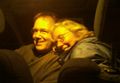
michael5000 and Mrs.5000 fail to reach the hashpoint east of Everett, after dark on 2009-11-27.
