Difference between revisions of "2009-12-16 50 12"
imported>Reinhard m (a new expedition! (report following)) |
imported>FippeBot m (Location) |
||
| (2 intermediate revisions by one other user not shown) | |||
| Line 6: | Line 6: | ||
}} | }} | ||
| − | [[User:Reinhard|Reinhard]] | + | == Participants == |
| + | * [[User:Reinhard|Reinhard]] | ||
| + | == Expedition == | ||
| + | I haven't been geohashing for over a month now and thought, that time had come for a new expedition! I had nothing special to do and Manu came home later that evening, so I had some spare time for the geohash in 50 12 graticule, which was partly on my way from Jena to Leipzig (with a detour of 26 km). It was snowing several times that day and temperature was at about -3°C/27°F, so getting to the hashpoint which was about 200 m on a field path and 80 m into the field shouldn't be too muddy. | ||
| − | <gallery caption="Photo Gallery" widths="200px" heights="200px" perrow=" | + | I parked the car in Korbußen, which is the first village after taking A4 exit Gera-Leumnitz. There I got into my bike clothes (wasn't sure, whether road conditions would allow me to cycle, when I started from work), took my road bike out of the car and went on the short trip to the hashpoint. Minor roads within small towns were still snow-covered, which was a bit tricky to ride on with 23 mm wide tires without profile, but I managed not to fall. Unfortunately, the autotimer photos didn't get so well. I cycled a circle around the hash field on the surrounding roads and then decided, which way to go on the field path leading close to the hashpoint. Of course, I had to push my bike through snow-covered grass on that path and left the bike alone for the last 80 m into the field. After taking a photo with the little Foxi, I got back to the bike and continued the short ride in order to defrost my hands. (I took off my gloves for taking the photo.) So I went on from Großenstein to Ronneburg, where I gave the [http://www.buga-gera.info/www/buga/buga07/impressionen/nlronneburg/ Neue Landschaft Ronneburg] a short visit and rode back to Korbußen on different roads, finishing the nice and cold evening bike trip after 26 km. |
| − | Image:20091216-50N12E-01.jpg|. | + | |
| − | Image:20091216-50N12E-02.jpg|. | + | --[[User:Reinhard|Reinhard]]. |
| − | Image:20091216-50N12E-03.jpg|. | + | |
| − | Image:20091216-50N12E-04.jpg| | + | |
| − | Image:20091216-50N12E-05.jpg|. | + | <gallery caption="Photo Gallery" widths="200px" heights="200px" perrow="3"> |
| + | Image:20091216-50N12E-01.jpg|Parked car and ready-to-slide bike. | ||
| + | Image:20091216-50N12E-02.jpg|Autotimer photo of me cycling away. | ||
| + | Image:20091216-50N12E-03.jpg|Bike waiting near the hashpoint. | ||
| + | Image:20091216-50N12E-04.jpg|Coordinates reached! | ||
| + | Image:20091216-50N12E-05.jpg|There we are. | ||
</gallery> | </gallery> | ||
| Line 20: | Line 28: | ||
[[Category:Expeditions with photos]] | [[Category:Expeditions with photos]] | ||
[[Category:Coordinates reached]] | [[Category:Coordinates reached]] | ||
| + | {{location|DE|TH|GRZ}} | ||
Latest revision as of 00:11, 9 August 2019
| Wed 16 Dec 2009 in 50,12: 50.9047030, 12.1838178 geohashing.info google osm bing/os kml crox |
Participants
Expedition
I haven't been geohashing for over a month now and thought, that time had come for a new expedition! I had nothing special to do and Manu came home later that evening, so I had some spare time for the geohash in 50 12 graticule, which was partly on my way from Jena to Leipzig (with a detour of 26 km). It was snowing several times that day and temperature was at about -3°C/27°F, so getting to the hashpoint which was about 200 m on a field path and 80 m into the field shouldn't be too muddy.
I parked the car in Korbußen, which is the first village after taking A4 exit Gera-Leumnitz. There I got into my bike clothes (wasn't sure, whether road conditions would allow me to cycle, when I started from work), took my road bike out of the car and went on the short trip to the hashpoint. Minor roads within small towns were still snow-covered, which was a bit tricky to ride on with 23 mm wide tires without profile, but I managed not to fall. Unfortunately, the autotimer photos didn't get so well. I cycled a circle around the hash field on the surrounding roads and then decided, which way to go on the field path leading close to the hashpoint. Of course, I had to push my bike through snow-covered grass on that path and left the bike alone for the last 80 m into the field. After taking a photo with the little Foxi, I got back to the bike and continued the short ride in order to defrost my hands. (I took off my gloves for taking the photo.) So I went on from Großenstein to Ronneburg, where I gave the Neue Landschaft Ronneburg a short visit and rode back to Korbußen on different roads, finishing the nice and cold evening bike trip after 26 km.
--Reinhard.
- Photo Gallery
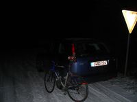
Parked car and ready-to-slide bike.

Autotimer photo of me cycling away.
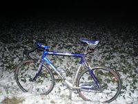
Bike waiting near the hashpoint.
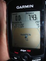
Coordinates reached!
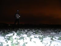
There we are.


