Difference between revisions of "2010-01-03 -37 145"
From Geohashing
imported>StephenEdmonds (Created page with '{{meetup graticule | map=<map lat="-37" lon="145" date="2010-01-03" /> | lat=-37 | lon=145 | date=2010-01-03 }} == The Place == Off in the bush south of Yarra Junction == Who…') |
imported>StephenEdmonds |
||
| Line 20: | Line 20: | ||
I walked from here and reached a point on the track that I deemed close enough, I wasn't dressed for bush bashing. | I walked from here and reached a point on the track that I deemed close enough, I wasn't dressed for bush bashing. | ||
| − | = | + | <gallery perrow="3"> |
| + | Image:2010-01-03_-37_145_that-way.jpg|Location is over that way | ||
| + | Image:2010-01-03_-37_145_relative-location.jpg|Relative location | ||
| + | Image:2010-01-03_-37_145_time-and-coords.jpg|Coordinates reached | ||
| + | </gallery> | ||
| + | |||
[[Category:Expeditions]] | [[Category:Expeditions]] | ||
[[Category:Expeditions with photos]] | [[Category:Expeditions with photos]] | ||
[[Category:Coordinates reached]] | [[Category:Coordinates reached]] | ||
Revision as of 10:39, 3 January 2010
| Sun 3 Jan 2010 in -37,145: -37.8488458, 145.6673194 geohashing.info google osm bing/os kml crox |
The Place
Off in the bush south of Yarra Junction
Who went
Stephen
As I was out at the Blue Lotus Water Garden near Yarra Junction it was a matter of convincing the driver to detour south on the Noojee road and wait while I walked closer to the location.
The actual location was a short distance from what Google called Fir Free Trk and the online Melways called the Fir Tree Track. I'd trust Melways for the correct name. Anyway, we reached a point on Mt Beenak Road where the track came close enough for there to be a clearing.
I walked from here and reached a point on the track that I deemed close enough, I wasn't dressed for bush bashing.
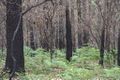
Location is over that way
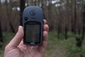
Relative location
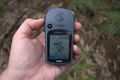
Coordinates reached


