Difference between revisions of "2010-01-21 36 -76"
From Geohashing
imported>Archer27 (→Participants) |
imported>FippeBot m (Location) |
||
| (9 intermediate revisions by one other user not shown) | |||
| Line 1: | Line 1: | ||
| − | |||
<!-- If you did not specify these parameters in the template, please substitute appropriate things for IMAGE, LAT, LON, and DATE (YYYY-MM-DD format) | <!-- If you did not specify these parameters in the template, please substitute appropriate things for IMAGE, LAT, LON, and DATE (YYYY-MM-DD format) | ||
| Line 15: | Line 14: | ||
__NOTOC__ | __NOTOC__ | ||
== Location == | == Location == | ||
| − | + | Chesapeake City Park, in the kid's playground area | |
== Participants == | == Participants == | ||
| − | [[User:Archer27|Archer27]] | + | *[[User:Archer27|Archer27]] |
| − | |||
| − | |||
| − | |||
== Expedition == | == Expedition == | ||
| + | You know what sucks? Work. So I decided to take some time today to blow off the job and goahead and get my FIRST geohash. | ||
| + | I drove down to the very convenient location in Chesapeake park. With overcast skies, some drizzling rain, and low temps there was no one there at all. I walked right into the deserted playground and found the coords. I left an hashmark arrow on the picnic table right there. | ||
| + | Upon returning to work, I awarded myself the prestigious "Dedication to Hashing Award" for my reasoned desicion to take time off to pick up a new hobby. | ||
| − | |||
| − | + | === Photos === | |
| − | == Photos == | + | ---- |
| − | + | <gallery> | |
| − | + | File:-f4084340-4e06-4f9b-8d35-3ad19c183303-.jpeg|Arrow and park | |
| − | <gallery | ||
| − | |||
| − | |||
</gallery> | </gallery> | ||
| − | |||
| + | === Acheivements === | ||
| + | ---- | ||
| − | + | {{land geohash | latitude = 36| longitude = -76| date = 2010-01-21 | name = [[User:archer27|Archer27]]}} | |
| − | [[ | ||
| − | |||
| − | |||
| − | |||
| − | |||
| − | |||
| − | |||
[[Category:Expeditions]] | [[Category:Expeditions]] | ||
| − | |||
| − | |||
| − | |||
| − | |||
| − | |||
| − | |||
| − | |||
[[Category:Coordinates reached]] | [[Category:Coordinates reached]] | ||
| − | + | {{location|US|VA|CS}} | |
| − | |||
| − | |||
| − | |||
| − | |||
| − | |||
| − | |||
| − | |||
| − | |||
| − | |||
Latest revision as of 00:33, 9 August 2019
| Thu 21 Jan 2010 in 36,-76: 36.7474641, -76.2267444 geohashing.info google osm bing/os kml crox |
Location
Chesapeake City Park, in the kid's playground area
Participants
Expedition
You know what sucks? Work. So I decided to take some time today to blow off the job and goahead and get my FIRST geohash. I drove down to the very convenient location in Chesapeake park. With overcast skies, some drizzling rain, and low temps there was no one there at all. I walked right into the deserted playground and found the coords. I left an hashmark arrow on the picnic table right there.
Upon returning to work, I awarded myself the prestigious "Dedication to Hashing Award" for my reasoned desicion to take time off to pick up a new hobby.
Photos
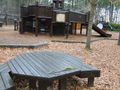
Arrow and park

Acheivements
Archer27 earned the Land geohash achievement
|