Difference between revisions of "2010-02-06 45 -122"
imported>Jiml (Expand Template) |
imported>FippeBot m (Location) |
||
| (6 intermediate revisions by one other user not shown) | |||
| Line 1: | Line 1: | ||
| − | |||
| − | |||
| − | |||
| − | |||
| − | |||
| − | |||
| − | |||
{{meetup graticule | {{meetup graticule | ||
| lat=45 | | lat=45 | ||
| Line 12: | Line 5: | ||
}} | }} | ||
| − | |||
| − | |||
== Location == | == Location == | ||
| − | + | ||
| + | A field on a farm near North Plains, Oregon. | ||
== Participants == | == Participants == | ||
| − | + | * [[User:Jiml|Jim]] | |
== Plans == | == Plans == | ||
| − | + | I programmed the GPS, and printed out a page from Google Maps. I never looked at them map. | |
| + | Maybe I shouldn't bother printing it | ||
| + | in this sort of case. | ||
| + | |||
== Expedition == | == Expedition == | ||
| − | + | It turned out pretty much like I expected. I arrived, and the hashpoint was clearly in a | |
| + | field. I went to ask at an adjacent house, which I think was the owner, but didn't find | ||
| + | anyone there, nor in the barn, except for a fairly friendly dog. | ||
| + | |||
| + | I tried to ask at the house across the street, and there was no one there either. | ||
| + | Since the hashpoint was a full 0.2 miles from the street, I decided it was too far | ||
| + | to go without permission. It wasn't like standing adjacent to the ditch at the side of the road. | ||
| + | |||
| + | So, I proceeded to run my errands and head home. | ||
| − | |||
| − | |||
== Photos == | == Photos == | ||
| − | + | ||
| − | <gallery perrow=" | + | <gallery perrow="2"> |
| − | Image: | + | Image:2010-02-06 45 -122-hashpoint.jpg | View of the hashpoint |
| − | |||
</gallery> | </gallery> | ||
| − | |||
| + | == Ribbon == | ||
| + | {{No trespassing | ||
| + | | latitude = 45 | ||
| + | | longitude = -122 | ||
| + | | date =2010-02-06 | ||
| + | | name = Jim | ||
| + | }} | ||
| − | |||
| − | |||
| − | |||
| − | |||
| − | |||
| − | |||
| − | |||
| − | |||
| − | |||
[[Category:Expeditions]] | [[Category:Expeditions]] | ||
| − | |||
[[Category:Expeditions with photos]] | [[Category:Expeditions with photos]] | ||
| − | |||
| − | |||
| − | |||
| − | |||
| − | |||
| − | |||
| − | |||
| − | |||
| − | |||
[[Category:Coordinates not reached]] | [[Category:Coordinates not reached]] | ||
| − | |||
| − | |||
[[Category:Not reached - No public access]] | [[Category:Not reached - No public access]] | ||
| − | + | {{location|US|OR|WI}} | |
| − | |||
| − | |||
Latest revision as of 00:45, 9 August 2019
| Sat 6 Feb 2010 in 45,-122: 45.6074741, -122.9902612 geohashing.info google osm bing/os kml crox |
Location
A field on a farm near North Plains, Oregon.
Participants
Plans
I programmed the GPS, and printed out a page from Google Maps. I never looked at them map. Maybe I shouldn't bother printing it in this sort of case.
Expedition
It turned out pretty much like I expected. I arrived, and the hashpoint was clearly in a field. I went to ask at an adjacent house, which I think was the owner, but didn't find anyone there, nor in the barn, except for a fairly friendly dog.
I tried to ask at the house across the street, and there was no one there either. Since the hashpoint was a full 0.2 miles from the street, I decided it was too far to go without permission. It wasn't like standing adjacent to the ditch at the side of the road.
So, I proceeded to run my errands and head home.
Photos
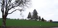
View of the hashpoint

Ribbon
Jim earned the No trespassing consolation prize
|