Difference between revisions of "2010-02-11 34.52 -110.10 (Unofficial)"
imported>Eylrid |
imported>Jiml m (Missing Image, Add result category) |
||
| Line 40: | Line 40: | ||
<gallery perrow="4"> | <gallery perrow="4"> | ||
Image:Dump_Close.JPG | Trash Heap. | Image:Dump_Close.JPG | Trash Heap. | ||
| − | |||
</gallery> | </gallery> | ||
| Line 47: | Line 46: | ||
[[Category:Expeditions with photos]] | [[Category:Expeditions with photos]] | ||
[[Category:Expedition without GPS]] | [[Category:Expedition without GPS]] | ||
| + | |||
| + | [[Category:Coordinates not reached]] | ||
| + | [[Category:Not reached - Did not attempt]] | ||
Revision as of 03:04, 13 February 2010
| Thu 11 Feb 2010 in 34,-110: 34.6277961, -110.1534468 geohashing.info google osm bing/os kml crox |
Participants
Plans
Expedition
This was my first expedition. I didn't have a way to get to the official hash, so I improvised. I used a point in a .05*.05 box: (34.527796 -110.103446). It turned out to be 6.5 km away. Even though none of it counts for anything official, I still did a few achievement like things.
I traveled there by bicycle. Because I didn't have a GPS, and I took only the most rudimentary hand drawn map, when I got out into the boonies I got a bit confused about which dirt roads to take. Somehow I managed to find my way to a stopping spot that turns out to have been about 100 m away from my target.
I found a dump site near where I stopped. I had to crawl under a gate to get to my spot.
I left the "Internet Was Here" sign, took some pictures, and ate some food.
The view: I could see a lot of nothing. I could see a long ways, but it was mostly barren.
I had an awesome time! It was quite enjoyable! Geohashing is such a brilliant idea. I am looking forward to doing official expeditions.
( More pictures later)
Photos
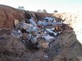
Trash Heap.
