Difference between revisions of "2010-02-20 51 9"
imported>Default |
imported>FippeBot m (Location) |
||
| (5 intermediate revisions by 2 users not shown) | |||
| Line 1: | Line 1: | ||
| − | |||
| − | |||
| − | |||
| − | |||
| − | |||
| − | |||
{{meetup graticule | {{meetup graticule | ||
| lat=51 | | lat=51 | ||
| Line 34: | Line 28: | ||
== Photos == | == Photos == | ||
| − | < | + | <gallery perrow="5"> |
| − | Image: | + | Image:2010-02-20-kassel-Greene castle.jpg | Greene castle, apparently they recently <strike>murdered</strike>chopped down a tree |
| − | -- | + | Image:2010-02-20-kassel-GPS.jpg | GPS reading at the hashpoint |
| − | + | File:2010-02-20-kassel-view from the hash.JPG | View from the hash point | |
| + | Image:2010-02-20-kassel-Default very stupid grin.jpg | Very stupid grin at the hash | ||
| + | Image:2010-02-20-kassel-the sun.jpg | Sun | ||
</gallery> | </gallery> | ||
| − | |||
| − | |||
| − | |||
| − | |||
| − | |||
| − | |||
| − | |||
| − | |||
| − | |||
[[Category:Expeditions]] | [[Category:Expeditions]] | ||
| Line 54: | Line 41: | ||
[[Category:Coordinates reached]] | [[Category:Coordinates reached]] | ||
| − | + | {{location|DE|NI|NOM}} | |
| − | |||
| − | |||
| − | |||
| − | |||
| − | |||
| − | |||
| − | |||
| − | |||
Latest revision as of 00:56, 9 August 2019
| Sat 20 Feb 2010 in 51,9: 51.8360114, 9.8260195 geohashing.info google osm bing/os kml crox |
Location
In a field south of Bartshausen and west of Einbeck.
Participants
User:Default is hoping for "good" weather to attempt his first geohash!
Plans
Go there before noon, by car. Survey dirt tracks in the area for OpenStreetMap, field test my Garmin. Don't get eaten by snow raptors.
Expedition
Starting shortly after noon, i drove through the snowy countryside, enjoying the occasional snowflake and my new car. Luckily, the sun broke through quite often.
I visited Greene Castle (german only, sorry) on the way. The castle has a very nice view over the valley of the Leine. Apart from the view, it's quite dull, because only some remnants remain, and a newly built tower (which was closed, which i found out after carefully ascending the iced steps to the entrance door). The tower features petitions for the release of german POWs after WW2. The commemorative plaque uses (in my opinion) language that could also have been used by the nazis (strong references to the Volk, see english wikipedia).
After the castle i drove on to the hash. It was located in the middle of a field, which had dirt tracs at the edges. At the precise point where i had to leave the track to go to the hash, some animal had also decided to cross into the field. Maybe animals do geohashing, too?
Carefully retracing my steps to confuse the farmer if he investigates the tracks in his field, i left the hashplace.
On the way back home i stopped at a gypsum karst area and had a nice evening walk.
Photos
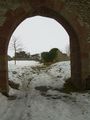
Greene castle, apparently they recently
murderedchopped down a tree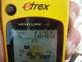
GPS reading at the hashpoint
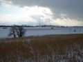
View from the hash point

Very stupid grin at the hash
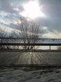
Sun


