Difference between revisions of "User:Phydeaux"
From Geohashing
imported>Phydeaux (→User:Phydeaux) |
imported>Phydeaux m (added SuperGrat image) |
||
| Line 1: | Line 1: | ||
| − | '''Brian''' needs to remember what the ''minor edit'' checkbox is for. | + | '''Brian, a/k/a Phydeaux''' needs to remember what the ''minor edit'' checkbox is for. |
== Serendipity == | == Serendipity == | ||
| − | Brian has been interested in geocaching since it was a new idea, but has never invested in a GPS unit. Until now. Last week he purchased a Garmin nuvi for a road trip, and this week XKCD rewards him with a way to use it. | + | Brian has been interested in geocaching since it was a new idea, but has never invested in a GPS unit. Until now. Last week he purchased a Garmin nuvi for a road trip, and this week XKCD rewards him with a way to use it. ~ [[User:Phydeaux|Phydeaux]] 02:07, 23 May 2008 (UTC) |
== Graticules of Interest == | == Graticules of Interest == | ||
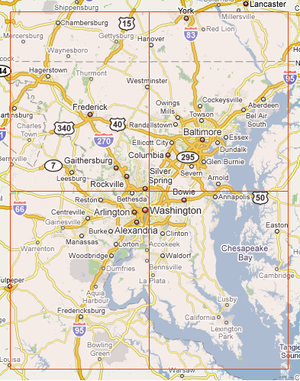
| + | [[Image:DC_Super_Grat.png|right|thumb|300px|Washington, DC Super-Graticule]] | ||
| + | |||
Brian works within spitting distance of the intersection of four graticules: | Brian works within spitting distance of the intersection of four graticules: | ||
* [[Frederick, Maryland|Montgomery County]] latitude 39, longitude -77 [[http://irc.peeron.com/xkcd/map/map.html?date={{LOCALYEAR}}-{{LOCALMONTH}}-{{LOCALDAY2}}&lat=39&long=-77&zoom=9&abs=-1 today]] | * [[Frederick, Maryland|Montgomery County]] latitude 39, longitude -77 [[http://irc.peeron.com/xkcd/map/map.html?date={{LOCALYEAR}}-{{LOCALMONTH}}-{{LOCALDAY2}}&lat=39&long=-77&zoom=9&abs=-1 today]] | ||
| Line 11: | Line 13: | ||
* [[Baltimore, Maryland|Baltimore]] latitude 39, longitude -76 [[http://irc.peeron.com/xkcd/map/map.html?date={{LOCALYEAR}}-{{LOCALMONTH}}-{{LOCALDAY2}}&lat=39&long=-76&zoom=9&abs=-1 today]] | * [[Baltimore, Maryland|Baltimore]] latitude 39, longitude -76 [[http://irc.peeron.com/xkcd/map/map.html?date={{LOCALYEAR}}-{{LOCALMONTH}}-{{LOCALDAY2}}&lat=39&long=-76&zoom=9&abs=-1 today]] | ||
* [[East Washington, District of Columbia|Annapolis & Kent Island]] latitude 38, longitude -76 [[http://irc.peeron.com/xkcd/map/map.html?date={{LOCALYEAR}}-{{LOCALMONTH}}-{{LOCALDAY2}}&lat=38&long=-76&zoom=9&abs=-1 today]] | * [[East Washington, District of Columbia|Annapolis & Kent Island]] latitude 38, longitude -76 [[http://irc.peeron.com/xkcd/map/map.html?date={{LOCALYEAR}}-{{LOCALMONTH}}-{{LOCALDAY2}}&lat=38&long=-76&zoom=9&abs=-1 today]] | ||
| − | |||
== Points of Interest == | == Points of Interest == | ||
| − | * '''Kent, 5/22/08:''' 38.973027°, -76.23891° Reachable (on land) | + | * '''Kent, 5/22/08:''' 38.973027°, -76.23891° Reachable (on land) on Kent Narrows. |
| − | * '''NoVa, 5/22/08:''' 38.973027°, -77.23891° Reachable | + | * '''NoVa, 5/22/08:''' 38.973027°, -77.23891° Reachable near Great Falls National Park. Check out this house: [http://maps.google.com/maps?f=q&hl=en&geocode=&q=38.972874%C2%B0,+-77.238697%C2%B0&ie=UTF8&ll=38.973027,-77.23891&spn=0.001456,0.002511&t=h&z=19 zoom] |
| − | * '''Balt, 5/21/08:''' 39.179467°, -76.861537° Reachable | + | * '''Balt, 5/21/08:''' 39.179467°, -76.861537° Reachable near Columbia, MD. |
Revision as of 02:07, 23 May 2008
Brian, a/k/a Phydeaux needs to remember what the minor edit checkbox is for.
Serendipity
Brian has been interested in geocaching since it was a new idea, but has never invested in a GPS unit. Until now. Last week he purchased a Garmin nuvi for a road trip, and this week XKCD rewards him with a way to use it. ~ Phydeaux 02:07, 23 May 2008 (UTC)
Graticules of Interest
Brian works within spitting distance of the intersection of four graticules:
- Montgomery County latitude 39, longitude -77 [today]
- Northern Virginia latitude 38, longitude -77 [today]
- Baltimore latitude 39, longitude -76 [today]
- Annapolis & Kent Island latitude 38, longitude -76 [today]
Points of Interest
- Kent, 5/22/08: 38.973027°, -76.23891° Reachable (on land) on Kent Narrows.
- NoVa, 5/22/08: 38.973027°, -77.23891° Reachable near Great Falls National Park. Check out this house: zoom
- Balt, 5/21/08: 39.179467°, -76.861537° Reachable near Columbia, MD.
