Difference between revisions of "2010-02-28 37 -122"
imported>FilipF (Initial creation) |
imported>FilipF (Inclusion of Filip's expedition report) |
||
| Line 1: | Line 1: | ||
| − | |||
<!-- If you did not specify these parameters in the template, please substitute appropriate things for IMAGE, LAT, LON, and DATE (YYYY-MM-DD format) | <!-- If you did not specify these parameters in the template, please substitute appropriate things for IMAGE, LAT, LON, and DATE (YYYY-MM-DD format) | ||
| Line 11: | Line 10: | ||
| date=2010-02-28 | | date=2010-02-28 | ||
}} | }} | ||
| − | + | After-action report on a quick expedition to one of the Noe Valley hills inside the city of San Francisco. | |
| − | + | Anyone else make it out? | |
__NOTOC__ | __NOTOC__ | ||
== Location == | == Location == | ||
| − | + | (Navigated based on Google Maps, gps didn't give a tight enough fix to pin down possibly alternative placement.) The location was found just a short bit up Hill St. from Church St., on the right hand side. It was the first driveway there, and apparently up against the short wall that extends to the sidewalk. Being on a slope with low buildings across the street and downhill, the spot provides a decent view of the Potrero and Bernal Heights areas. | |
== Participants == | == Participants == | ||
| − | + | * [[User:FilipF|Filip]] - Solo runner, no group, no contact with suspected geohashers. | |
| − | |||
| − | |||
== Expedition == | == Expedition == | ||
| − | + | === Filip === | |
| − | + | This was an unplanned and spontaneous expedition. I somehow overlooked this hash when reading the [http://groups.google.com/group/sfsj-geohash mailing list] on Friday (I suspect it was right when I woke up :P), so it wasn't until I was rechecking the points for kicks on Sunday that I noticed that there was one a short walk away ''right now''. Since it was the first one (I believe) that was in the city since I started keeping track, I had to go reach it just for myself. I grabbed my DSLR despite the fast falling darkness and lack of a tripod, and wandered over. My gps wasn't getting a tight enough fix, so I wasn't able to confirm that the google maps pinmark matched reality, but I took some scenery-stabilized long exposures of where it was predicted. | |
| − | == | + | No explanatory sign made up this time. All in all, an unexpected but still fun (and easy >.<) start to geohashing! |
| − | |||
== Photos == | == Photos == | ||
| − | + | Run through Lightroom to tweak the white-balance, then exported to 1024x768 JPGs at 80 quality. Apologies for the shaky city shot. | |
| − | |||
| − | |||
<gallery perrow="4"> | <gallery perrow="4"> | ||
| + | Image:2010-02-28 37 -122 Geohash.jpg|Photo of the driveway, home to today's hash point. | ||
| + | Image:2010-02-28 37 -122 View.jpg|View from sidewalk near hash point. | ||
| + | Image:2010-02-28 37 -122 Map.png|Google Maps view, for posterity. | ||
</gallery> | </gallery> | ||
| Line 47: | Line 44: | ||
<!-- An actual expedition: | <!-- An actual expedition: | ||
| − | + | ... | |
-- and one or more of -- | -- and one or more of -- | ||
| − | [[Category:Expeditions with photos]] | + | [[Category:Expeditions with photos]] (Once added, to be accurate) |
| − | + | ... | |
| − | |||
--> | --> | ||
| + | [[Category:Expeditions]] | ||
| − | |||
[[Category:Coordinates reached]] | [[Category:Coordinates reached]] | ||
| − | |||
| − | |||
| − | |||
| − | |||
| − | |||
| − | |||
| − | |||
| − | |||
| − | |||
| − | |||
Revision as of 07:07, 1 March 2010
| Sun 28 Feb 2010 in 37,-122: 37.7557524, -122.4283349 geohashing.info google osm bing/os kml crox |
After-action report on a quick expedition to one of the Noe Valley hills inside the city of San Francisco. Anyone else make it out?
Location
(Navigated based on Google Maps, gps didn't give a tight enough fix to pin down possibly alternative placement.) The location was found just a short bit up Hill St. from Church St., on the right hand side. It was the first driveway there, and apparently up against the short wall that extends to the sidewalk. Being on a slope with low buildings across the street and downhill, the spot provides a decent view of the Potrero and Bernal Heights areas.
Participants
- Filip - Solo runner, no group, no contact with suspected geohashers.
Expedition
Filip
This was an unplanned and spontaneous expedition. I somehow overlooked this hash when reading the mailing list on Friday (I suspect it was right when I woke up :P), so it wasn't until I was rechecking the points for kicks on Sunday that I noticed that there was one a short walk away right now. Since it was the first one (I believe) that was in the city since I started keeping track, I had to go reach it just for myself. I grabbed my DSLR despite the fast falling darkness and lack of a tripod, and wandered over. My gps wasn't getting a tight enough fix, so I wasn't able to confirm that the google maps pinmark matched reality, but I took some scenery-stabilized long exposures of where it was predicted. No explanatory sign made up this time. All in all, an unexpected but still fun (and easy >.<) start to geohashing!
Photos
Run through Lightroom to tweak the white-balance, then exported to 1024x768 JPGs at 80 quality. Apologies for the shaky city shot.
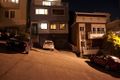
Photo of the driveway, home to today's hash point.
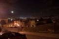
View from sidewalk near hash point.
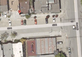
Google Maps view, for posterity.


