Difference between revisions of "2010-03-03 -37 145"
From Geohashing
imported>Kozz (→Expedition) |
imported>Kozz (→Photos) |
||
| Line 34: | Line 34: | ||
== Photos == | == Photos == | ||
| − | |||
| − | |||
| − | |||
<gallery perrow="4"> | <gallery perrow="4"> | ||
| + | Image:2010_03_03_-37_145 Approaching point.JPG | Approaching hashpoint | ||
| + | Image:2010_03_03_-37_145-Aerial-vs-Actual.JPG| Aerial photo vs actual location | ||
| + | Image:2010_03_03_-37_145 Location achieved.JPG | Point reached | ||
| + | Image:2010_03_03_-37_145 The hashpoint on the stripe.JPG | Looking back at point | ||
| + | Image:2010_03_03_-37_145 Looking back.jpg | Looking back at point - wider angle | ||
| + | Image:2010-03-03_-37_145_Route.jpg | Route taken | ||
</gallery> | </gallery> | ||
| − | |||
| − | |||
| − | |||
| − | |||
| − | |||
| − | |||
| − | |||
| − | |||
| − | |||
| − | |||
[[Category:Expeditions]] | [[Category:Expeditions]] | ||
| − | |||
[[Category:Expeditions with photos]] | [[Category:Expeditions with photos]] | ||
[[Category:Expeditions with videos]] | [[Category:Expeditions with videos]] | ||
| − | |||
| − | |||
| − | |||
| − | |||
[[Category:Coordinates reached]] | [[Category:Coordinates reached]] | ||
| − | |||
| − | |||
| − | |||
| − | |||
| − | |||
| − | |||
| − | |||
| − | |||
| − | |||
| − | |||
Revision as of 00:43, 3 March 2010
| Wed 3 Mar 2010 in -37,145: -37.9361539, 145.2426752 geohashing.info google osm bing/os kml crox |
Location
On an intersection in suburbia, Rowville
Participants
Plans
Quick drive by in the morning
Expedition
- Yawn* boring old hash down in suburbia. This is the closest one to me for ages so I kinda had to do it. Decided to make it interesting and do a Tron, heading down via tollway then back up via suburbia.
The actual spot was easy to find, pretty much exactly where Google said it would be. I stopped and took a few pictures but there wasn't anything of any note nearby. I did get some very suspicious looks from nearby neighbours whilst taking the photos, too. There's a school nearby, they probably thought I was a stalker or someting.
Drove out a different way, then zig zagged through streets till I got back onto a main road and all the way home. Round trip of just over an hour, all told.
Tracklog
Photos

Approaching hashpoint
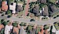
Aerial photo vs actual location
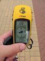
Point reached
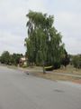
Looking back at point
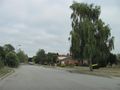
Looking back at point - wider angle
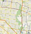
Route taken


