Difference between revisions of "2010-03-09 40 -89"
imported>Dvdllr |
imported>FippeBot m (Location) |
||
| (5 intermediate revisions by one other user not shown) | |||
| Line 1: | Line 1: | ||
| − | + | __NOTOC__ | |
| − | |||
| − | |||
| − | |||
| − | |||
| − | |||
{{meetup graticule | {{meetup graticule | ||
| lat=40 | | lat=40 | ||
| Line 10: | Line 5: | ||
| date=2010-03-09 | | date=2010-03-09 | ||
}} | }} | ||
| − | |||
| − | |||
| − | |||
== Location == | == Location == | ||
| − | + | Someone's front yard on Hires Trace, Morton | |
== Participants == | == Participants == | ||
| − | [[User:Dvdllr|Dvdllr]] | + | * [[User:Dvdllr|Dvdllr]] & not Rachel |
== Plans == | == Plans == | ||
| − | I | + | Another hash that's not too far from where I work/live. The only plans were to drive by in the afternoon after work. Preparation included bringing an Ambassador form and GPS! |
| − | |||
== Expedition == | == Expedition == | ||
| + | Spring! It's gettin' here. [http://www.qwantz.com/index.php?comic=1669 Today's Dinosaur Comic] made me happy because that's exactly how I feel. I was verrry close to riding my bike to the hashpoint today, but alas, it is only March 9, and it would have been dark by the time I got there - and I'd rather be snooping around someone's house in the light than when it's dark with a flashlight. Also, it was rather windy as a rainstorm was coming in, so a combination of all these factors led me to drive there. Satellite views of this area are terrible, so I didn't know what to expect, but I imagined it was some kind of residential area. Hence, the Ambassador form. | ||
| + | |||
| + | So Rachel and I arrive on the street, and I'm driving down the right side of the road to see if the longitude half of the point was actually on the road or if it was on the lawns. It ended up being in front of someone's house, so I parked the car and went up and rang the doorbell. Rachel stayed in the car, because she was just too nervous to be doing this level of snooping. No one answered the door after ringing twice, so I shrugged at Rachel, still sitting in the passenger seat, and took a look at the front yard. There were these landscaping-style stepping stones going out from the driveway towards the hashpoint, so I thought I would try the stones to see if it got me close enough. | ||
| + | Meanwhile, shifting perspectives to Rachel, here's her husband coming back from the front door, shrugging, and setting out into the yard. Then she sees the blinds open up on one of the windows, and a guy looking out, watching. So she's still in the car, freaking out, while I am wandering obliviously in the yard. I love my wife dearly, but she's not exactly the geohashing type, if you get the picture. | ||
| − | + | So I found the spot, and took a photo. Huzzah! Then from across the street, this loose dog comes bounding out and stands in the middle of the street, barking his fool head off at me. I snapped another photo, but I was done lingering, as I didn't want to tick off the nice doggy any more than he already was. So I went back towards the driveway, and here's the homeowner, standing in front of his house. | |
| + | Right away I started to explain how I was on a scavenger hunt type of game and my destination coordinates were in his front yard, along with apologies for not talking to him beforehand, and how I'd rang the doorbell, etc... Fortunately, the guy was totally nice. He said he was fine with whatever I was doing. He said that he figured I was some kind of tax assessor and he was just glad I wasn't there to levy any more property taxes. And with that, he went back in, not a care in the world what I did next. Awesome! But I was done there, and my wife was still panicking in the car, so I went back, told her everything's cool, and drove back home. | ||
== Photos == | == Photos == | ||
| − | <gallery perrow=" | + | <gallery perrow="5"> |
| − | Image: | + | Image:2010-03-09 40 -89 1.jpg | Good ol' Morton, a nice place to live |
| + | Image:2010-03-09 40 -89 2.jpg | Street, road, avenue, boulevard...trace? I don't know what that is | ||
| + | Image:2010-03-09 40 -89 3.jpg | Geohash location: right about on that stick in the grass | ||
| + | Image:2010-03-09 40 -89 4.jpg | Here I am (date and time info in the metadata) | ||
| + | Image:2010-03-09 40 -89 5.jpg | Get offa muh street! | ||
| + | Image:2010-03-09 40 -89 6.jpg | Geohashers | ||
</gallery> | </gallery> | ||
| − | |||
| − | [[ | + | == Achievements == |
| + | {{#vardefine:ribbonwidth|800px}} | ||
| + | {{land geohash | ||
| + | |||
| + | | latitude = 40 | ||
| + | | longitude = -89 | ||
| + | | date = 2010-03-09 | ||
| + | | name = [[User:Dvdllr|Dvdllr]] | ||
| + | }} | ||
| + | {{A Tale of Two Hashes | ||
| + | |||
| + | | latitude = 40 | ||
| + | | longitude = -89 | ||
| + | | completed = yes | ||
| + | | date = 2010-03-09 | ||
| + | | name = [[User:Dvdllr|Dvdllr]] | ||
| + | | user2 = [[User:Haberdasher|Haberdasher]] | ||
| + | | place = Morton (Arboretum) | ||
| + | }} | ||
| + | {{Ambassador geohash | ||
| + | |||
| + | | latitude = 40 | ||
| + | | longitude = -89 | ||
| + | | date = 2010-03-09 | ||
| + | | name = [[User:Dvdllr|Dvdllr]] | ||
| + | }} | ||
| − | |||
[[Category:Expeditions]] | [[Category:Expeditions]] | ||
| − | |||
[[Category:Expeditions with photos]] | [[Category:Expeditions with photos]] | ||
| − | |||
| − | |||
| − | |||
| − | |||
| − | |||
[[Category:Coordinates reached]] | [[Category:Coordinates reached]] | ||
| − | + | {{location|US|IL|TA}} | |
| − | |||
| − | |||
| − | |||
| − | |||
| − | |||
| − | |||
| − | |||
| − | |||
| − | |||
Latest revision as of 01:07, 9 August 2019
| Tue 9 Mar 2010 in 40,-89: 40.6473975, -89.4874414 geohashing.info google osm bing/os kml crox |
Location
Someone's front yard on Hires Trace, Morton
Participants
- Dvdllr & not Rachel
Plans
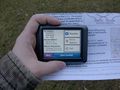
Another hash that's not too far from where I work/live. The only plans were to drive by in the afternoon after work. Preparation included bringing an Ambassador form and GPS!
Expedition
Spring! It's gettin' here. Today's Dinosaur Comic made me happy because that's exactly how I feel. I was verrry close to riding my bike to the hashpoint today, but alas, it is only March 9, and it would have been dark by the time I got there - and I'd rather be snooping around someone's house in the light than when it's dark with a flashlight. Also, it was rather windy as a rainstorm was coming in, so a combination of all these factors led me to drive there. Satellite views of this area are terrible, so I didn't know what to expect, but I imagined it was some kind of residential area. Hence, the Ambassador form.
So Rachel and I arrive on the street, and I'm driving down the right side of the road to see if the longitude half of the point was actually on the road or if it was on the lawns. It ended up being in front of someone's house, so I parked the car and went up and rang the doorbell. Rachel stayed in the car, because she was just too nervous to be doing this level of snooping. No one answered the door after ringing twice, so I shrugged at Rachel, still sitting in the passenger seat, and took a look at the front yard. There were these landscaping-style stepping stones going out from the driveway towards the hashpoint, so I thought I would try the stones to see if it got me close enough.
Meanwhile, shifting perspectives to Rachel, here's her husband coming back from the front door, shrugging, and setting out into the yard. Then she sees the blinds open up on one of the windows, and a guy looking out, watching. So she's still in the car, freaking out, while I am wandering obliviously in the yard. I love my wife dearly, but she's not exactly the geohashing type, if you get the picture.
So I found the spot, and took a photo. Huzzah! Then from across the street, this loose dog comes bounding out and stands in the middle of the street, barking his fool head off at me. I snapped another photo, but I was done lingering, as I didn't want to tick off the nice doggy any more than he already was. So I went back towards the driveway, and here's the homeowner, standing in front of his house.
Right away I started to explain how I was on a scavenger hunt type of game and my destination coordinates were in his front yard, along with apologies for not talking to him beforehand, and how I'd rang the doorbell, etc... Fortunately, the guy was totally nice. He said he was fine with whatever I was doing. He said that he figured I was some kind of tax assessor and he was just glad I wasn't there to levy any more property taxes. And with that, he went back in, not a care in the world what I did next. Awesome! But I was done there, and my wife was still panicking in the car, so I went back, told her everything's cool, and drove back home.
Photos
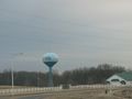
Good ol' Morton, a nice place to live
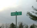
Street, road, avenue, boulevard...trace? I don't know what that is
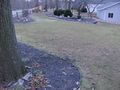
Geohash location: right about on that stick in the grass
Here I am (date and time info in the metadata)
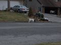
Get offa muh street!
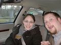
Geohashers


Achievements
Dvdllr earned the Land geohash achievement
|

Dvdllr earned the Ambassador achievement
|