Difference between revisions of "2010-03-19 45 -123"
imported>Jiml (Expand template) |
imported>FippeBot m (Location) |
||
| (4 intermediate revisions by one other user not shown) | |||
| Line 1: | Line 1: | ||
| − | |||
| − | |||
| − | |||
| − | |||
| − | |||
| − | |||
| − | |||
{{meetup graticule | {{meetup graticule | ||
| lat=45 | | lat=45 | ||
| − | | lon=- | + | | lon=-123 |
| date=2010-03-19 | | date=2010-03-19 | ||
}} | }} | ||
| Line 15: | Line 8: | ||
__NOTOC__ | __NOTOC__ | ||
== Location == | == Location == | ||
| − | + | In a Gales Creek, Oregon roadway, in a creek valley. | |
== Participants == | == Participants == | ||
| − | + | * [[User:Jiml|Jim]] | |
== Plans == | == Plans == | ||
| − | + | I printed out the Google map page and programmed the GPS. | |
== Expedition == | == Expedition == | ||
| − | |||
| − | + | I finally finished up at work, and decided I'd make a try for | |
| − | + | this hashpoint. It looked like it was off the road, but didn't | |
| + | appear to be too far off. | ||
| + | |||
| + | APR wasn't interested in driving country roads, so I went off | ||
| + | by myself. The route was very scenic. I was thinking it would still be | ||
| + | a little light by the time I got there, but I was mistaken as I headed | ||
| + | into stream valleys and hills. | ||
| + | |||
| + | The road turned into gravel, and I glanced over as the GPS hit 74 feet, so I | ||
| + | stopped, and walked over. The hashpoint was in the roadway, at least what | ||
| + | my GPS could deduce through the tree cover. So, I took some pictures, and | ||
| + | went up the road so I could pass through the hashpoint for a Speed Racer. | ||
| + | I didn't bring a real camera, so I had to make do with my cellphone, which was | ||
| + | less than perfect. | ||
| + | |||
| + | I didn't make too much noise and disturb the nearby house, though it looked | ||
| + | uninhabited. I headed back home, trying out the "backtrack" function of | ||
| + | my GPS. | ||
== Photos == | == Photos == | ||
| − | + | ||
| − | |||
| − | |||
<gallery perrow="4"> | <gallery perrow="4"> | ||
| + | Image:2010-03-19_45_-123-forest.jpg | The nearby forest | ||
| + | Image:2010-03-19_45_-123-gps.jpg | The GPS showing I made it | ||
| + | Image:2010-03-19_45_-123-road.jpg | A view further up the road | ||
| + | Image:2010-03-19_45_-123-view.jpg | A view the other way into the woods | ||
</gallery> | </gallery> | ||
| − | |||
| − | |||
| − | |||
| − | |||
| − | |||
| − | |||
| − | |||
| − | |||
| − | |||
| − | |||
[[Category:Expeditions]] | [[Category:Expeditions]] | ||
| − | + | [[Category:Expeditions with photos]] | |
| − | [[Category:Expeditions with photos]] | ||
| − | |||
| − | |||
| − | |||
| − | |||
| − | |||
[[Category:Coordinates reached]] | [[Category:Coordinates reached]] | ||
| − | + | {{location|US|OR|WI}} | |
| − | |||
| − | |||
| − | |||
| − | |||
| − | |||
| − | |||
| − | |||
| − | |||
| − | |||
Latest revision as of 01:15, 9 August 2019
| Fri 19 Mar 2010 in 45,-123: 45.5696440, -123.2364307 geohashing.info google osm bing/os kml crox |
Location
In a Gales Creek, Oregon roadway, in a creek valley.
Participants
Plans
I printed out the Google map page and programmed the GPS.
Expedition
I finally finished up at work, and decided I'd make a try for this hashpoint. It looked like it was off the road, but didn't appear to be too far off.
APR wasn't interested in driving country roads, so I went off by myself. The route was very scenic. I was thinking it would still be a little light by the time I got there, but I was mistaken as I headed into stream valleys and hills.
The road turned into gravel, and I glanced over as the GPS hit 74 feet, so I stopped, and walked over. The hashpoint was in the roadway, at least what my GPS could deduce through the tree cover. So, I took some pictures, and went up the road so I could pass through the hashpoint for a Speed Racer. I didn't bring a real camera, so I had to make do with my cellphone, which was less than perfect.
I didn't make too much noise and disturb the nearby house, though it looked uninhabited. I headed back home, trying out the "backtrack" function of my GPS.
Photos
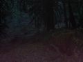
The nearby forest
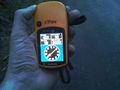
The GPS showing I made it
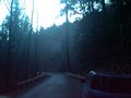
A view further up the road

A view the other way into the woods


