Difference between revisions of "2009-11-07 19 -99"
imported>Cid (Created page with '{{subst:Expedition |lat = 19 |lon = -99 |date = 2009-11-07 }}') |
imported>Cid |
||
| Line 1: | Line 1: | ||
| − | |||
<!-- If you did not specify these parameters in the template, please substitute appropriate things for IMAGE, LAT, LON, and DATE (YYYY-MM-DD format) | <!-- If you did not specify these parameters in the template, please substitute appropriate things for IMAGE, LAT, LON, and DATE (YYYY-MM-DD format) | ||
| Line 12: | Line 11: | ||
}} | }} | ||
| − | |||
__NOTOC__ | __NOTOC__ | ||
== Location == | == Location == | ||
| − | + | Near the crater of the [http://en.wikipedia.org/wiki/Nevado_de_Toluca Xinantécatl] (Nevado de Toluca), an inactive volcano . A few hundred meters from the National Park ''Parque de los Venados''. | |
== Participants == | == Participants == | ||
| − | + | [[User:Cid|Cid]] and Paddy... my dog =D | |
== Plans == | == Plans == | ||
| − | + | In order to get to the volcano you need to take the road to Valle de Bravo vía Cacalomacán; half the way you get to an intersection, right to Valle de Bravo, left to Xinantécatl. After half an hour from the intersection you get to choose between a narrow road that takes you to the south of the state or a dirty road that takes you to the Parque de los Venados, last point before reaching the volcano. | |
| + | |||
| + | Because of the proximity to Toluca, many people visit this zone. The volcano is a good place to visit with your family and friends on a weekend, trying some outdoor activities, forgetting about the city and breathing some fresh air. You can practice hiking, bicycle, jogging, camping, etc. So, the plan was to wake up around 5am in order to hit the road as soon as possible, avoiding '''annoying''' visitors. | ||
== Expedition == | == Expedition == | ||
| − | + | I promise to come back tomorrow and finish this part, REALLY REALLY REALLY! | |
| + | just a few points to say meanwhile: | ||
| + | |||
| + | * Point reached in a zone with little (crappy) satellite signal, so coordinates and altitude might had an error (with a tolerance to consider) | ||
| + | * Google Earth says the point is at 3960msnm, the GPS said 3923msnm... which one is considered as official data? | ||
| + | * Point reached with my dog (who wasn't sure why we were there taking pictures). Do we get somekind of achievement for this? Fluffy achievement? | ||
== Tracklog == | == Tracklog == | ||
| − | + | The GPS i used for this expedition is not mine, it's of my girlfriend's father =S | |
| + | Of course I tried and pushed all the buttons but I didn't investigate all the features... I don't know if i was able to record a log or not =/ | ||
== Photos == | == Photos == | ||
| − | |||
| − | |||
| − | |||
<gallery perrow="4"> | <gallery perrow="4"> | ||
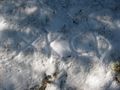
| + | Image:20091107 19 -99 GPS.JPG | Coordinates reached | ||
| + | Image:20091107 19 -99 Altitud.jpg | 3923msnm, Highest point achievement? | ||
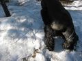
| + | Image:20091107 19 -99 Paddy.JPG | Fluffy geohasher near the point | ||
| + | Image:20091107 19 -99 PaddyCid.JPG | A nice squirrel helped to take this picture | ||
| + | Image:20091107 19 -99 XKCD.JPG | A tribute to the mesiah | ||
| + | Image:20091107 19 -99 PaddyXKCD.JPG | Padfoot destroying a good work | ||
</gallery> | </gallery> | ||
| − | |||
| − | |||
| − | |||
[[Category:New report]] | [[Category:New report]] | ||
| − | |||
| − | |||
| − | |||
| − | |||
| − | |||
| − | |||
| − | |||
[[Category:Expeditions]] | [[Category:Expeditions]] | ||
| − | |||
[[Category:Expeditions with photos]] | [[Category:Expeditions with photos]] | ||
| − | |||
| − | |||
| − | |||
| − | |||
| − | |||
[[Category:Coordinates reached]] | [[Category:Coordinates reached]] | ||
| − | |||
| − | |||
| − | |||
| − | |||
| − | |||
| − | |||
| − | |||
| − | |||
| − | |||
| − | |||
Revision as of 05:51, 23 March 2010
| Sat 7 Nov 2009 in 19,-99: 19.1274876, -99.7789729 geohashing.info google osm bing/os kml crox |
Location
Near the crater of the Xinantécatl (Nevado de Toluca), an inactive volcano . A few hundred meters from the National Park Parque de los Venados.
Participants
Cid and Paddy... my dog =D
Plans
In order to get to the volcano you need to take the road to Valle de Bravo vía Cacalomacán; half the way you get to an intersection, right to Valle de Bravo, left to Xinantécatl. After half an hour from the intersection you get to choose between a narrow road that takes you to the south of the state or a dirty road that takes you to the Parque de los Venados, last point before reaching the volcano.
Because of the proximity to Toluca, many people visit this zone. The volcano is a good place to visit with your family and friends on a weekend, trying some outdoor activities, forgetting about the city and breathing some fresh air. You can practice hiking, bicycle, jogging, camping, etc. So, the plan was to wake up around 5am in order to hit the road as soon as possible, avoiding annoying visitors.
Expedition
I promise to come back tomorrow and finish this part, REALLY REALLY REALLY! just a few points to say meanwhile:
- Point reached in a zone with little (crappy) satellite signal, so coordinates and altitude might had an error (with a tolerance to consider)
- Google Earth says the point is at 3960msnm, the GPS said 3923msnm... which one is considered as official data?
- Point reached with my dog (who wasn't sure why we were there taking pictures). Do we get somekind of achievement for this? Fluffy achievement?
Tracklog
The GPS i used for this expedition is not mine, it's of my girlfriend's father =S Of course I tried and pushed all the buttons but I didn't investigate all the features... I don't know if i was able to record a log or not =/
Photos
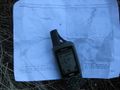
Coordinates reached
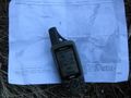
3923msnm, Highest point achievement?
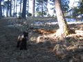
Fluffy geohasher near the point
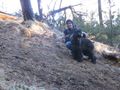
A nice squirrel helped to take this picture
A tribute to the mesiah
Padfoot destroying a good work


