Difference between revisions of "2010-04-01 48 -123"
imported>Wenslayer (first draft) |
imported>Wenslayer (Add photos) |
||
| Line 32: | Line 32: | ||
Forthcoming... | Forthcoming... | ||
| − | < | + | <gallery perrow="3"> |
| − | Image: | + | Image:2010-04-01 48 -123 GPS.jpg | GPS showing the coordinates were reached. |
| − | + | Image:2010-04-01 48 -123 Wenslayer.jpg | Your intrepid Geohasher, looking slightly unsure whether the photo will turn out. | |
| + | Image:2010-04-01 48 -123 bike.jpg | My bike, looking east from the Geohash coordinate down Lost Lake Road. | ||
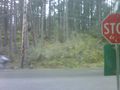
| + | Image:2010-04-01 48 -123 sign.jpg | The Lost Lake Road street sign across the road from the Geohash. | ||
| + | Image:2010-04-01 48 -123 From-across-road.jpg | View of the Geohash coordinate from across the road. | ||
</gallery> | </gallery> | ||
| − | |||
[[Category:Expeditions]] | [[Category:Expeditions]] | ||
| + | [[Category:Expeditions with photos]] | ||
<!-- and one or more of | <!-- and one or more of | ||
| − | |||
| − | |||
[[Category:Expedition without GPS]] | [[Category:Expedition without GPS]] | ||
--> | --> | ||
[[Category:Coordinates reached]] | [[Category:Coordinates reached]] | ||
Revision as of 04:30, 3 April 2010
| Thu 1 Apr 2010 in 48,-123: 48.4900747, -123.5103400 geohashing.info google osm bing/os kml crox |
Location
Just off Millstream Road where it intersects with Lost Lake Road, about 4km north of the Costco in Langford.
Participants
Plans
I had planned to simply bike there after work, turn around and then head home.
Expedition
I left work about a quarter to five, with ominous skies threatening. About 10 minutes into my ride, I felt the first drops and thoughts of abandoning the expedition. But no! I needed a workout anyway (I've committed to doing the Whistler Gran Fondo in September), and so I pedalled on. The rain came on, but it wasn't until I started north on Millstream Road where the water had started accumulating on the road and so that's where I start getting a nice rooster tail up my back. After a few kilometres, the road really quiets down and you feel quite "out there". The rain also let up to intermittent drops.
My GPS compass swung around to let me know I had briefly overshot the location, so I U-turned, and parked my bike against a telephone pole. I was within 20 metres of the spot from the road, so I scrambled up into the forest to locate the position, took some photos (including of the intersection), and continued on my way.
I had thought I would simply retrace my steps afterward, but I got a crazy idea to sort of "Tron" it and continue north on Millstream Road to West Saanich and then head home. Keep in mind I hadn't been on Millstream road this way in over 10 years, but I recalled there were some pretty tight corners and steep hills. I recalled correctly. Going over one particularly steep hill, I had to stand up while pedalling in my lowest gear for what seemed like 5 whole minutes, and disappointingly had to take a breather.
I didn't quite know the way, although I had a hunch. Fortunately, I ended up making a wrong turn for the better: I ended up onto Munns Road, leading me back to Burnside -> Helmecken -> Wilkinson and then on home. I was pretty pooped, and my calves were tightening up (cold rain on bare legs), so I'm glad I took the shorter path home.
A hot shower at home to defrost my numb feet was just the remedy I needed.
Tracklog
Forthcoming...
Photos
Forthcoming...
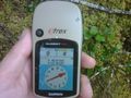
GPS showing the coordinates were reached.
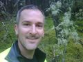
Your intrepid Geohasher, looking slightly unsure whether the photo will turn out.
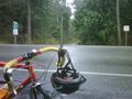
My bike, looking east from the Geohash coordinate down Lost Lake Road.
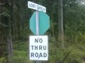
The Lost Lake Road street sign across the road from the Geohash.
View of the Geohash coordinate from across the road.


