Difference between revisions of "2010-04-04 42 -82"
imported>CaptainSpam ([live picture] The point itself. There's a residential area right behind it. [http://www.openstreetmap.org/?lat=42.5552&lon=-82.9115&zoom=16&layers=B000FTF @42.5552,-82.9115]) |
imported>FippeBot m (Location) |
||
| (2 intermediate revisions by one other user not shown) | |||
| Line 1: | Line 1: | ||
| − | |||
<!-- If you did not specify these parameters in the template, please substitute appropriate things for IMAGE, LAT, LON, and DATE (YYYY-MM-DD format) | <!-- If you did not specify these parameters in the template, please substitute appropriate things for IMAGE, LAT, LON, and DATE (YYYY-MM-DD format) | ||
| Line 15: | Line 14: | ||
__NOTOC__ | __NOTOC__ | ||
== Location == | == Location == | ||
| − | + | Any time I return home to visit my parents for a holiday or whatnot, I always check the nearest hashpoint just in case. Southeastern Michigan IS considerably more developed and urban than central Kentucky, so there's a lot less "middle of nowhere" to be seen. The only problem is that this graticule also happens to include much of Lake St. Clair, which makes up for the advantage of not being thirty or so miles out in the middle of the abyss. | |
| + | |||
| + | Today, however, luck hit, and the point was just about two miles away, right on the corner of 15 Mile Road and Little Mack in the Baker College area. Satellite View on Google Maps showed it to be behind a small strip mall nearby. While this wasn't a particularly long or adventurous expedition, it was an expedition of opportunity, and I had a few new features in Geohash Droid I've been developing that needed some good real-world testing. | ||
== Participants == | == Participants == | ||
| − | + | *[[User:CaptainSpam|CaptainSpam]] | |
== Plans == | == Plans == | ||
| − | + | Plans were simple: The point was about two miles away and in a residential area, so I just drove. Easy, yet effective. | |
== Expedition == | == Expedition == | ||
| − | |||
| − | |||
| − | |||
*Well now, this is interesting. Visiting my parents for Easter, and today's point is right nearby! I ought to take advantage of this and test some new features in Geohash Droid. Should be a quick trip... -- [[User:CaptainSpam|CaptainSpam]] [http://www.openstreetmap.org/?lat=42.52491116523743&lon=-82.93106496334076&zoom=16&layers=B000FTF @42.5249,-82.9311] 19:15, 4 April 2010 (UTC) | *Well now, this is interesting. Visiting my parents for Easter, and today's point is right nearby! I ought to take advantage of this and test some new features in Geohash Droid. Should be a quick trip... -- [[User:CaptainSpam|CaptainSpam]] [http://www.openstreetmap.org/?lat=42.52491116523743&lon=-82.93106496334076&zoom=16&layers=B000FTF @42.5249,-82.9311] 19:15, 4 April 2010 (UTC) | ||
| Line 32: | Line 30: | ||
*Well, here I am, behind a small strip mall near the corner of 15 and Little Mack. Said strip mall consists of a laundromat, a smoke shop, and a sandwich shop. It's here in the Baker College area of Southeastern Michigan. -- [[User:CaptainSpam|CaptainSpam]] [http://www.openstreetmap.org/?lat=42.5552898645401&lon=-82.91173696517944&zoom=16&layers=B000FTF @42.5553,-82.9117] 19:38, 4 April 2010 (UTC) | *Well, here I am, behind a small strip mall near the corner of 15 and Little Mack. Said strip mall consists of a laundromat, a smoke shop, and a sandwich shop. It's here in the Baker College area of Southeastern Michigan. -- [[User:CaptainSpam|CaptainSpam]] [http://www.openstreetmap.org/?lat=42.5552898645401&lon=-82.91173696517944&zoom=16&layers=B000FTF @42.5553,-82.9117] 19:38, 4 April 2010 (UTC) | ||
| − | |||
| − | |||
== Photos == | == Photos == | ||
| − | |||
| − | |||
| − | |||
<gallery perrow="4"> | <gallery perrow="4"> | ||
| Line 48: | Line 41: | ||
</gallery> | </gallery> | ||
| − | |||
| − | |||
| − | |||
| − | |||
| − | |||
| − | |||
| − | |||
| − | |||
| − | |||
| − | |||
| − | |||
[[Category:Expeditions]] | [[Category:Expeditions]] | ||
| − | |||
[[Category:Expeditions with photos]] | [[Category:Expeditions with photos]] | ||
| − | + | ||
| − | |||
| − | |||
| − | |||
| − | |||
[[Category:Coordinates reached]] | [[Category:Coordinates reached]] | ||
| − | + | {{location|US|MI|MB}} | |
| − | |||
| − | |||
| − | |||
| − | |||
| − | |||
| − | |||
| − | |||
| − | |||
| − | |||
Latest revision as of 01:28, 9 August 2019
| Sun 4 Apr 2010 in 42,-82: 42.5553332, -82.9117472 geohashing.info google osm bing/os kml crox |
Location
Any time I return home to visit my parents for a holiday or whatnot, I always check the nearest hashpoint just in case. Southeastern Michigan IS considerably more developed and urban than central Kentucky, so there's a lot less "middle of nowhere" to be seen. The only problem is that this graticule also happens to include much of Lake St. Clair, which makes up for the advantage of not being thirty or so miles out in the middle of the abyss.
Today, however, luck hit, and the point was just about two miles away, right on the corner of 15 Mile Road and Little Mack in the Baker College area. Satellite View on Google Maps showed it to be behind a small strip mall nearby. While this wasn't a particularly long or adventurous expedition, it was an expedition of opportunity, and I had a few new features in Geohash Droid I've been developing that needed some good real-world testing.
Participants
Plans
Plans were simple: The point was about two miles away and in a residential area, so I just drove. Easy, yet effective.
Expedition
- Well now, this is interesting. Visiting my parents for Easter, and today's point is right nearby! I ought to take advantage of this and test some new features in Geohash Droid. Should be a quick trip... -- CaptainSpam @42.5249,-82.9311 19:15, 4 April 2010 (UTC)
- Huh. I wonder why autozoom isn't working. -- CaptainSpam @42.5552,-82.9114 19:30, 4 April 2010 (UTC)
- Well, here I am, behind a small strip mall near the corner of 15 and Little Mack. Said strip mall consists of a laundromat, a smoke shop, and a sandwich shop. It's here in the Baker College area of Southeastern Michigan. -- CaptainSpam @42.5553,-82.9117 19:38, 4 April 2010 (UTC)
Photos
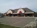
The strip mall behind which the point sat. @42.5546,-82.9115
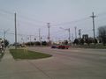
The corner of 15 Mile Road and Little Mack. @42.5546,-82.9111
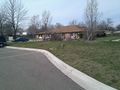
The point itself. There's a residential area right behind it. @42.5552,-82.9115


