Difference between revisions of "2010-04-06 33 -113"
imported>Gila Monster (→Plans) |
imported>FippeBot m (Location) |
||
| (8 intermediate revisions by 3 users not shown) | |||
| Line 14: | Line 14: | ||
__NOTOC__ | __NOTOC__ | ||
== Location == | == Location == | ||
| − | Tonopah, AZ, within a posted BLM | + | Tonopah, AZ, within a posted BLM Wilderness Area north of the west end of town. |
== Participants == | == Participants == | ||
| Line 24: | Line 24: | ||
== Expedition == | == Expedition == | ||
| − | + | Another one fairly close to home. Donning sandals and hats, [[User:SkinWalker|SkinWalker]] and [[User:Gila_Monster|Gila Monster]] hit the road. About ten miles of driving, virtually all on dirt and gravel roads of varying quality. Eventually we got to the closest point we could on the road, about 0.74 miles from the hashpoint, and parked the truck. There was a 600 foot high hill just this side of the hash point; we decided we'd go around rather than over the hill (both of us having already been "over the hill"). Traversing varied terrain, we made our way to the hill, passing Ajo Lilies, poppies, flowering Hedgehog cacti, and more. The surface was mostly flat, if rocky in places, except for the occasional wash. We finally made it around the hill, and followed the GPS. It seems the hashpoint was not only "behind" the hill, but partially up it as well. We found the hashpoint, Tux found a nest in a Teddy Bare Cactus, and [[User:SkinWalker|SkinWalker]] found a geode. | |
| + | |||
| + | For the hike back to the truck, we decided that since we were already part way up the hill, it would be shorter to go the rest of the way up and over rather than back down and around. It was a moderately steep descent; just steep enough to be challenging, with a few patches of loose rock along the way. I'm not sure if either route was "better", but taking a different return route certainly added variety. | ||
| + | |||
| + | After we got back to the truck, we took a short drive further down the road to see "the windmill" - a watering station for the cattle who freely graze this Wilderness Area. We were pleasantly surprised to see about two dozen head of cattle, including several calves, hanging around waiting for us to come take photos. | ||
| + | |||
| + | By then we decided we'd better head back home while there was still some sunlight left. | ||
== Tracklog == | == Tracklog == | ||
| Line 30: | Line 36: | ||
== Photos == | == Photos == | ||
| − | + | ||
| − | |||
| − | |||
| − | |||
<gallery perrow="4"> | <gallery perrow="4"> | ||
| + | |||
| + | Image:2010-04-06_33_-113_sign1.JPG | ||
| + | |||
| + | Image:2010-04-06_33_-113_hedgehog.JPG | Hedgehog Cactus | ||
| + | |||
Image:2010-04-06_33_-113_SkinWalker.JPG | SkinWalker & Tux | Image:2010-04-06_33_-113_SkinWalker.JPG | SkinWalker & Tux | ||
| − | |||
| + | Image:2010-04-06_33_-113_Gila_Monster.jpg | Gila Monster & Tux | ||
| + | |||
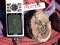
| + | Image:2010-04-06_33_-113_geode.jpg | G is for GPS and Geode! | ||
| + | |||
| + | Image:2010-04-06_33_-113_cattle1.jpg | ||
| + | |||
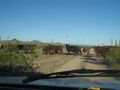
| + | Image:2010-04-06_33_-113_cattle2.JPG | Cattle Crossing | ||
| − | < | + | </gallery> |
| − | |||
| − | |||
| − | |||
| − | |||
| − | |||
| − | |||
| − | |||
[[Category:Expeditions]] | [[Category:Expeditions]] | ||
| − | + | ||
[[Category:Expeditions with photos]] | [[Category:Expeditions with photos]] | ||
| − | + | ||
| − | |||
| − | |||
| − | |||
| − | |||
[[Category:Coordinates reached]] | [[Category:Coordinates reached]] | ||
| − | + | {{location|US|AZ|MA}} | |
| − | |||
| − | |||
| − | |||
| − | |||
| − | |||
| − | |||
| − | |||
| − | |||
| − | |||
Latest revision as of 01:31, 9 August 2019
| Tue 6 Apr 2010 in 33,-113: 33.6020716, -113.0849708 geohashing.info google osm bing/os kml crox |
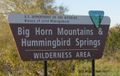
Location
Tonopah, AZ, within a posted BLM Wilderness Area north of the west end of town.
Participants
Plans
Close by and accessible with about 10 miles of dirt road driving plus three quarters of a mile hike each way. Should be do-able
Expedition
Another one fairly close to home. Donning sandals and hats, SkinWalker and Gila Monster hit the road. About ten miles of driving, virtually all on dirt and gravel roads of varying quality. Eventually we got to the closest point we could on the road, about 0.74 miles from the hashpoint, and parked the truck. There was a 600 foot high hill just this side of the hash point; we decided we'd go around rather than over the hill (both of us having already been "over the hill"). Traversing varied terrain, we made our way to the hill, passing Ajo Lilies, poppies, flowering Hedgehog cacti, and more. The surface was mostly flat, if rocky in places, except for the occasional wash. We finally made it around the hill, and followed the GPS. It seems the hashpoint was not only "behind" the hill, but partially up it as well. We found the hashpoint, Tux found a nest in a Teddy Bare Cactus, and SkinWalker found a geode.
For the hike back to the truck, we decided that since we were already part way up the hill, it would be shorter to go the rest of the way up and over rather than back down and around. It was a moderately steep descent; just steep enough to be challenging, with a few patches of loose rock along the way. I'm not sure if either route was "better", but taking a different return route certainly added variety.
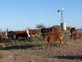
After we got back to the truck, we took a short drive further down the road to see "the windmill" - a watering station for the cattle who freely graze this Wilderness Area. We were pleasantly surprised to see about two dozen head of cattle, including several calves, hanging around waiting for us to come take photos.
By then we decided we'd better head back home while there was still some sunlight left.
Tracklog
Photos
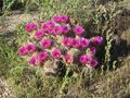
Hedgehog Cactus
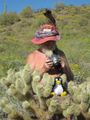
SkinWalker & Tux
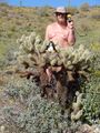
Gila Monster & Tux
G is for GPS and Geode!
Cattle Crossing


