Difference between revisions of "2010-04-10 48 11"
From Geohashing
imported>DerFlob (new, successful expedition, template) |
imported>DerFlob (pics, cats, plans) |
||
| Line 1: | Line 1: | ||
| − | |||
<!-- If you did not specify these parameters in the template, please substitute appropriate things for IMAGE, LAT, LON, and DATE (YYYY-MM-DD format) | <!-- If you did not specify these parameters in the template, please substitute appropriate things for IMAGE, LAT, LON, and DATE (YYYY-MM-DD format) | ||
| Line 21: | Line 20: | ||
== Plans == | == Plans == | ||
| − | + | 2010-04-10: Even though it's on private ground The T-Man and me will visit it around 4 p.m. -DerFlob 00:36, 10 April 2010 (UTC) -- This would be a really easy one, but I'm not in town this afternoon, so I won't come. You might like to take this challenge, though. --Zb 09:34, 10 April 2010 (UTC) | |
== Expedition == | == Expedition == | ||
<!-- how it all turned out. your narrative goes here. --> | <!-- how it all turned out. your narrative goes here. --> | ||
| − | |||
| − | |||
== Photos == | == Photos == | ||
| Line 34: | Line 31: | ||
--> | --> | ||
<gallery perrow="4"> | <gallery perrow="4"> | ||
| + | Image:2010-04-10_48_11_Flob_01.jpg | This is the garden where the geohash is located | ||
| + | Image:2010-04-10_48_11_Flob_02.jpg | About 15m away from outside | ||
| + | Image:2010-04-10_48_11_Flob_03.jpg | After we gain permission, we reached the coords | ||
| + | Image:2010-04-10_48_11_Flob_04.jpg | | ||
| + | Image:2010-04-10_48_11_Flob_05.jpg | Backside of the [http://en.wikipedia.org/wiki/SV-Hochhaus Hochhaus Süddeutscher Verlag] | ||
| + | Image:2010-04-10_48_11_Flob_05.jpg | Frontview of the [http://en.wikipedia.org/wiki/SV-Hochhaus SV-Hochhaus] | ||
</gallery> | </gallery> | ||
| + | |||
| + | == Achievement ribbons == | ||
| + | {{Ambassador geohash | ||
| + | | latitude = 48 | ||
| + | | longitude = 11 | ||
| + | | date = 2010-04-10 | ||
| + | | granter = name of person or agency granting permission (optional) | ||
| + | | name = The T-Man and DerFlob | ||
| + | | image = image name (optional) | ||
| + | |||
| + | }} | ||
<!-- =============== USEFUL CATEGORIES FOLLOW ================ | <!-- =============== USEFUL CATEGORIES FOLLOW ================ | ||
| Line 41: | Line 55: | ||
[[Category:New report]] | [[Category:New report]] | ||
| − | |||
| − | |||
| − | |||
| − | |||
| − | |||
[[Category:Expeditions]] | [[Category:Expeditions]] | ||
| − | + | [[Category:Expeditions with photos]] | |
| − | [[Category:Expeditions with photos]] | ||
| − | |||
| − | |||
| − | |||
| − | |||
| − | |||
[[Category:Coordinates reached]] | [[Category:Coordinates reached]] | ||
| − | |||
| − | |||
| − | |||
| − | |||
| − | |||
| − | |||
| − | |||
| − | |||
| − | |||
| − | |||
Revision as of 15:06, 10 April 2010
| Sat 10 Apr 2010 in 48,11: 48.1513277, 11.6384178 geohashing.info google osm bing/os kml crox |
Location
Participants
Plans
2010-04-10: Even though it's on private ground The T-Man and me will visit it around 4 p.m. -DerFlob 00:36, 10 April 2010 (UTC) -- This would be a really easy one, but I'm not in town this afternoon, so I won't come. You might like to take this challenge, though. --Zb 09:34, 10 April 2010 (UTC)
Expedition
Photos
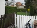
This is the garden where the geohash is located
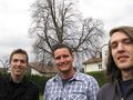
About 15m away from outside
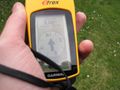
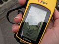
After we gain permission, we reached the coords
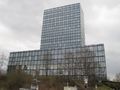
Backside of the Hochhaus Süddeutscher Verlag
Frontview of the SV-Hochhaus


Achievement ribbons
The T-Man and DerFlob earned the Ambassador achievement
|