Difference between revisions of "2010-04-20 33 -84"
From Geohashing
imported>NWoodruff |
imported>FippeBot m (Location) |
||
| (One intermediate revision by one other user not shown) | |||
| Line 23: | Line 23: | ||
==== Gallery ==== | ==== Gallery ==== | ||
<gallery perrow="3"> | <gallery perrow="3"> | ||
| − | Image:2010042033-84NW01.JPG | | + | Image:2010042033-84NW01.JPG | 4.28 feet to go. Close enough. |
| + | Image:2010042033-84NW02.JPG | Time of the meetup. | ||
| + | Image:2010042033-84NW03.JPG | Date of the meetup. | ||
| + | Image:2010042033-84NW04.JPG | 18 feet accuracy. Good enough. | ||
| + | Image:2010042033-84NW05.JPG | Looking west into the woods. | ||
| + | Image:2010042033-84NW06.JPG | Looking North and Me with a Stupid Grin™ | ||
</gallery> | </gallery> | ||
| Line 35: | Line 40: | ||
[[Category:Expeditions with photos]] | [[Category:Expeditions with photos]] | ||
[[Category:Coordinates reached]] | [[Category:Coordinates reached]] | ||
| + | {{location|US|GA|DL}} | ||
Latest revision as of 01:41, 9 August 2019
| Tue 20 Apr 2010 in Atlanta: 33.6616994, -84.8442336 geohashing.info google osm bing/os kml crox |
Graticule
About
Off to the side of a driveway south of Douglasville.
Expedition
NWoodruff
Gallery
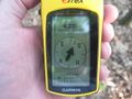
4.28 feet to go. Close enough.
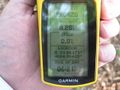
Time of the meetup.
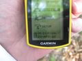
Date of the meetup.
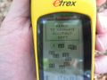
18 feet accuracy. Good enough.
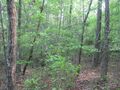
Looking west into the woods.

Looking North and Me with a Stupid Grin™


LuxMundi
NWoodruff earned the Land geohash achievement
|