Difference between revisions of "2010-04-21 42 -83"
From Geohashing
imported>Jiml (Expand report from entry sent in) |
imported>Jiml m (Adjust Result codes - sounds like it was successful) |
||
| Line 1: | Line 1: | ||
| − | |||
| − | |||
| − | |||
| − | |||
| − | |||
| − | |||
{{meetup graticule | {{meetup graticule | ||
| lat=42 | | lat=42 | ||
| Line 40: | Line 34: | ||
</gallery> | </gallery> | ||
| − | |||
| − | |||
| − | |||
| − | |||
| − | |||
[[Category:Expeditions]] | [[Category:Expeditions]] | ||
| − | |||
| − | |||
| − | |||
| − | |||
| − | |||
| − | |||
| − | |||
[[Category:Coordinates reached]] | [[Category:Coordinates reached]] | ||
| − | |||
| − | |||
| − | |||
| − | |||
| − | |||
| − | |||
| − | |||
| − | |||
| − | |||
| − | |||
Revision as of 06:17, 17 May 2010
| Wed 21 Apr 2010 in 42,-83: 42.3404859, -83.3514034 geohashing.info google osm bing/os kml crox |
Location
Hines Park - someone said it was an easy location.
Participants
Plans
Unknown
Expedition
The coordinates on the picture suggest that someone got there, or got very close.
Photos
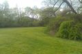
Easy location in Hines Park. @42.3406,-83.3514
