Difference between revisions of "2010-04-21 42 -83"
From Geohashing
imported>Mkhopper (a live expedition message sent via geohashdroid for android.) |
imported>FippeBot m (Location) |
||
| (3 intermediate revisions by 2 users not shown) | |||
| Line 1: | Line 1: | ||
| − | |||
| − | |||
| − | |||
| − | |||
| − | |||
| − | |||
| − | |||
{{meetup graticule | {{meetup graticule | ||
| lat=42 | | lat=42 | ||
| Line 16: | Line 9: | ||
== Location == | == Location == | ||
<!-- where you've surveyed the hash to be --> | <!-- where you've surveyed the hash to be --> | ||
| + | Hines Park - someone said it was an easy location. | ||
== Participants == | == Participants == | ||
<!-- who attended --> | <!-- who attended --> | ||
| + | * [[User:Mkhopper]] | ||
== Plans == | == Plans == | ||
<!-- what were the original plans --> | <!-- what were the original plans --> | ||
| + | Unknown | ||
| + | |||
== Expedition == | == Expedition == | ||
<!-- how it all turned out. your narrative goes here. --> | <!-- how it all turned out. your narrative goes here. --> | ||
| + | The coordinates on the picture suggest that someone got there, or got very close. | ||
| + | |||
| + | <!-- Nothing in this section currently > | ||
== Tracklog == | == Tracklog == | ||
<!-- if your GPS device keeps a log, you may post a link here --> | <!-- if your GPS device keeps a log, you may post a link here --> | ||
| − | == Photos == | + | == Photos == |
| − | < | + | <gallery> |
| − | Image: | + | Image:2010-04-21_42_-83_18-05-19-797.jpg | Easy location in Hines Park. [http://www.openstreetmap.org/?lat=42.34058976173401&lon=-83.35143148899078&zoom=16&layers=B000FTF @42.3406,-83.3514] |
| − | -- | ||
| − | |||
</gallery> | </gallery> | ||
| + | |||
| − | |||
| − | |||
| − | |||
| − | |||
| − | |||
| − | |||
| − | |||
| − | |||
| − | |||
| − | |||
[[Category:Expeditions]] | [[Category:Expeditions]] | ||
| − | |||
| − | |||
| − | |||
| − | |||
| − | |||
| − | |||
| − | |||
[[Category:Coordinates reached]] | [[Category:Coordinates reached]] | ||
| − | + | {{location|US|MI|WY}} | |
| − | |||
| − | |||
| − | |||
| − | |||
| − | |||
| − | |||
| − | |||
| − | |||
| − | |||
Latest revision as of 01:41, 9 August 2019
| Wed 21 Apr 2010 in 42,-83: 42.3404859, -83.3514034 geohashing.info google osm bing/os kml crox |
Location
Hines Park - someone said it was an easy location.
Participants
Plans
Unknown
Expedition
The coordinates on the picture suggest that someone got there, or got very close.
Photos
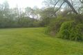
Easy location in Hines Park. @42.3406,-83.3514
