Difference between revisions of "2010-04-24 46 6"
From Geohashing
imported>Crox (planning) |
imported>FippeBot m (Location) |
||
| (4 intermediate revisions by 2 users not shown) | |||
| Line 1: | Line 1: | ||
| − | {{meetup graticule | + | {{meetup graticule |
| lat=46 | | lat=46 | ||
| lon=6 | | lon=6 | ||
| Line 5: | Line 5: | ||
}} | }} | ||
| − | == | + | __NOTOC__ |
| − | [ | + | == Location == |
| + | In what used to be an (apple?) orchard in Prangins. The location can be seen on [http://maps.google.com/maps?q=loc:(46.398318,6.264564)&ie=UTF8&ll=46.400269,6.259761&spn=0.008242,0.022724&t=h&z=16&layer=c&cbll=46.399666,6.26532&panoid=-yNfwKE0D2zMJFKXSOx5DQ&cbp=12,200.03,,0,5 Google street view] | ||
| − | [ | + | == Participants == |
| + | * [[User:Crox]] | ||
| + | * his father | ||
| + | |||
| + | == Expedition == | ||
| + | [[User:Crox]] cycled to Prangins where he was joined by his father. Shortly before hash-o-clock they drove towards the Eastern part of the village where the hash is located. As it turned out, there were no more trees in the field that used to be an orchard. [[User:Crox]] and his father reached the place exactly on time at 16:00. Unfortunately nobody else joined them despite the nice weather and the very accessible location. | ||
| + | |||
| + | == Photos == | ||
| + | <gallery perrow="4"> | ||
| + | Image:2010-04-24_46_6_geohashers.jpg | [[User:Crox]] and his father at the hash | ||
| + | Image:2010-04-24_46_6_pano_fused.jpg | view from the hash | ||
| + | </gallery> | ||
| + | |||
| + | |||
| + | |||
| + | [[Category:Expeditions]] | ||
| + | [[Category:Expeditions with photos]] | ||
| + | [[Category:Coordinates reached]] | ||
| + | {{location|CH|VD}} | ||
Latest revision as of 01:45, 9 August 2019
| Sat 24 Apr 2010 in 46,6: 46.3983182, 6.2645639 geohashing.info google osm bing/os kml crox |
Location
In what used to be an (apple?) orchard in Prangins. The location can be seen on Google street view
Participants
- User:Crox
- his father
Expedition
User:Crox cycled to Prangins where he was joined by his father. Shortly before hash-o-clock they drove towards the Eastern part of the village where the hash is located. As it turned out, there were no more trees in the field that used to be an orchard. User:Crox and his father reached the place exactly on time at 16:00. Unfortunately nobody else joined them despite the nice weather and the very accessible location.
Photos
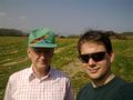
User:Crox and his father at the hash
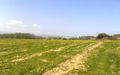
view from the hash

