Difference between revisions of "2010-05-09 32 -111"
From Geohashing
imported>Wyle & RoadRunner (Created page with '{{meetup graticule | lat=32 | lon=-111 | date=2010-05-09 | graticule_name=Casa Grande | graticule_link=Casa Grande, Arizona}} == Location == Sahuaro National Park - West == Pa…') |
imported>Wyle & RoadRunner m |
||
| Line 20: | Line 20: | ||
Image:2010-05-09_32_-111_gps.jpg|Casa Grande, Arizona | Image:2010-05-09_32_-111_gps.jpg|Casa Grande, Arizona | ||
Image:2010-05-09_32_-111_view.jpg|Casa Grande, Arizona | Image:2010-05-09_32_-111_view.jpg|Casa Grande, Arizona | ||
| + | Image:2010-05-09_32_-111_cholla.jpg|Casa Grande, Arizona | ||
Image:2010-05-09_32_-111_track.jpg|Casa Grande, Arizona | Image:2010-05-09_32_-111_track.jpg|Casa Grande, Arizona | ||
</gallery> | </gallery> | ||
Revision as of 04:50, 10 May 2010
| Sun 9 May 2010 in Casa Grande: 32.3330888, -111.1312620 geohashing.info google osm bing/os kml crox |
Location
Sahuaro National Park - West
Participants
- Wyle
- Roadrunner
Expeditions
Oh, man. Its been 3+ month since a geohash, but what a wonderful one today. Almost in RoadRunners back yard and right on the boundary (literally at the fence) of Sauharo National Park (West). A small jaunt up and over the ridge and then down through the dry wash into the flatland. A slightly different trek out and it was back to the car. No cactus encounters (except for RoadRunner's sunglasses and Wyle's hat), but lots of cholla in bloom.
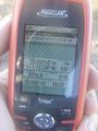
Casa Grande, Arizona
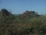
Casa Grande, Arizona
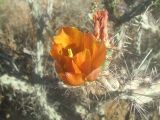
Casa Grande, Arizona
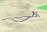
Casa Grande, Arizona


