Difference between revisions of "2010-05-16 49 9"
imported>Danatar |
imported>Danatar (+tracklog) |
||
| Line 31: | Line 31: | ||
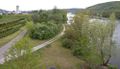
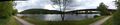
Image:2010-05-16_49_9_pano.jpg|The Main at the hashpoint | Image:2010-05-16_49_9_pano.jpg|The Main at the hashpoint | ||
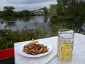
Image:2010-05-16_49_9_pause.jpg|HUNGER! | Image:2010-05-16_49_9_pause.jpg|HUNGER! | ||
| − | Image:2010-05-16_49_9_ziegen.jpg| | + | Image:2010-05-16_49_9_ziegen.jpg|Goats |
Image:2010-05-16_49_9_benediktus.jpg|St. Benediktus at Retzbach | Image:2010-05-16_49_9_benediktus.jpg|St. Benediktus at Retzbach | ||
</gallery> | </gallery> | ||
| + | |||
| + | ==Tracklog== | ||
| + | [http://www.everytrail.com/view_trip.php?trip_id=631782&code=419b9e862e1ccea8e24e802e08ec0b1d http://www.everytrail.com/view_trip.php?trip_id=631782] | ||
[[Category:Expeditions]] | [[Category:Expeditions]] | ||
Revision as of 09:07, 24 May 2010
| Sun 16 May 2010 in Würzburg: 49.9723779, 9.7647325 geohashing.info google osm bing/os kml crox |
Location
Today's location is next to the Main river near Karlstadt am Main.
Country: Germany; state: Bayern (Bavaria, EU:DE:BY); administrative region: Unterfranken; district: Main-Spessart
Weather: sunny with many clouds, 14 °C
Expedition
Danatar
My first bicycle geohash in 8 months! It was far, but I was sure I could make it. Some time ago, a friend told me about the cycle track on the Main's north side. Until now I had always taken a detour to the south side, but today I found the new route. After a little more climbing than planned due to a wrong turn I reached Veitshöchheim, where I had been almost defeated the last time I had been there by bike (2009-05-28 49 9). Now that I knew the route, I continued to Himmelstadt. Biking was difficult and I was exhausted even after the first 15 km, but I thought that lack of training was responsible for that, and stopped a few times to rest. At Himmelstadt I crossed the Main, knowing that this would disqualify my planned tron route, but I couldn't continue on the right side of the river. After more painful kilometres, I reached the bridge next to the geohash, which is visible on google maps but not on the satellite view. Then I was at the hashpoint. It was about 3 metres into the bushes from a track along the main. I waved my camera around in order to look like I belonged there, but I guess the people that saw me had their own thoughts about what I was doing.
I cycled to Karlstadt and crossed the Main again. While carrying the bike up some stairs I found out that the bike's dynamo had been running all the last 32 kilometres, making the bright day even brighter by draining my stamina. No wonder I had been tired for while... Suddenly, cycling was much easier. In a Biergarten I had seen on the way there I stopped for a Gyros and a Radler. Then I mostly followed my own route back home.
Distance by bike: 61 km (30.8 + 30.2)
The hashpoint is in the bushes
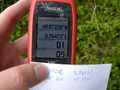
GPS

Coordinates reached
The Main at the hashpoint
HUNGER!
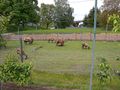
Goats
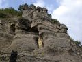
St. Benediktus at Retzbach


