Difference between revisions of "2010-05-22 48 8"
From Geohashing
imported>Ekorren (Been there at 4 pm. Finally my dry spell comes to an end. Report and pics will be added later.) |
imported>FippeBot m (Location) |
||
| (One intermediate revision by one other user not shown) | |||
| Line 20: | Line 20: | ||
<gallery> | <gallery> | ||
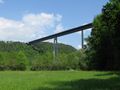
| + | File:2010-05-22_48_8_BrueckeEyach.jpg|The bridge at Eyach always makes a majestic sight. | ||
| + | File:2010-05-22_48_8_BrueckeEyach_2.jpg | ||
| + | File:2010-05-22_48_8_TrainE2.jpg|Something's wrong with that train? | ||
| + | File:2010-05-22_48_8_Way_to_Hash.jpg|The hash is over there, at the bushes | ||
| + | File:2010-05-22_48_8_GPS.jpg|Coordinates reached (for a sufficient value of "reached") at 4 pm | ||
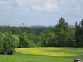
| + | File:2010-05-22_48_8_View_from_Hash.jpg|View from hash | ||
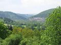
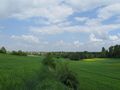
| + | File:2010-05-22_48_8_View_near_Hash.jpg|Another landscape impression near the hash | ||
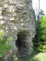
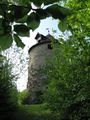
| + | File:2010-05-22_48_8_Urnburg.jpg|Urnburg castle leftovers | ||
| + | File:2010-05-22_48_8_Urnburg_Entrance.jpg | ||
</gallery> | </gallery> | ||
| Line 27: | Line 36: | ||
[[Category:Expeditions with photos]] | [[Category:Expeditions with photos]] | ||
[[Category:Coordinates reached]] | [[Category:Coordinates reached]] | ||
| + | {{location|DE|BW|FDS}} | ||
Latest revision as of 02:07, 9 August 2019
| Sat 22 May 2010 in 48,8: 48.4635260, 8.7646015 geohashing.info google osm bing/os kml crox |
Contents
Location
A field near Rohrdorf, municipality Eutingen im Gäu.
Participants
Expedition
Gallery
The bridge at Eyach always makes a majestic sight.
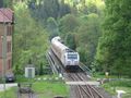
Something's wrong with that train?
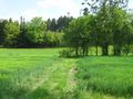
The hash is over there, at the bushes
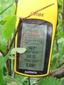
Coordinates reached (for a sufficient value of "reached") at 4 pm
View from hash
Another landscape impression near the hash
Urnburg castle leftovers