Difference between revisions of "2010-06-05 53 10"
imported>Pne (Expedition) |
imported>Pne (images) |
||
| Line 3: | Line 3: | ||
If I have time, I ([[User:Pne|Pne]]) may attempt to meet up there for 16:00. | If I have time, I ([[User:Pne|Pne]]) may attempt to meet up there for 16:00. | ||
| − | + | [[Image:{{{image|2010-06-05 53 10 field.jpg}}}|thumb|left]] | |
| − | |||
| − | [[Image:{{{image| | ||
| − | |||
| − | |||
| − | |||
{{meetup graticule | {{meetup graticule | ||
| lat=53 | | lat=53 | ||
| Line 17: | Line 12: | ||
}} | }} | ||
| − | |||
__NOTOC__ | __NOTOC__ | ||
== Location == | == Location == | ||
| Line 41: | Line 35: | ||
== Photos == | == Photos == | ||
| − | + | (I see that I forgot to switch my camera over to summer time, so the EXIF data shows that they were taken around 15:00 rather than around 16:00.) | |
| − | |||
| − | |||
<gallery perrow="5"> | <gallery perrow="5"> | ||
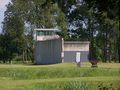
| + | Image:2010-06-05 53 10 field.jpg | View of the field with the geohash from the bus stop | ||
| + | Image:2010-06-05 53 10 GPS.jpg | Image of my satnav showing the exact meetup coordinates (to five decimal places) | ||
| + | Image:2010-06-05 53 10 stupid grin.jpg | Obligatory stupid grin | ||
| + | Image:2010-06-05 53 10 view southeast.jpg | View to the southeast from the geohash position | ||
| + | Image:2010-06-05 53 10 view southwest.jpg | View to the southwest from the geohash position | ||
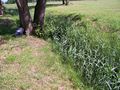
| + | Image:2010-06-05 53 10 barbed wire.jpg | View to the east from the geohash position: a portion of the original(?) concrete wall with barbed wire on top | ||
| + | Image:2010-06-05 53 10 brick factory.jpg | View to the northeast from the geohash position: brick factory | ||
| + | Image:2010-06-05 53 10 brick factory ramp.jpg | View to the northeast from the geohash: ramp of the brick factory | ||
</gallery> | </gallery> | ||
Revision as of 16:40, 5 June 2010
Close to the concentration camp memorial in Neuengamme -- judging by Google Maps, on a field near a parking area. Possibly accessible.
If I have time, I (Pne) may attempt to meet up there for 16:00.

| Sat 5 Jun 2010 in Hamburg (East): 53.4318804, 10.2300218 geohashing.info google osm bing/os kml crox |
Location
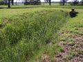
The location was on the bank of a drainage ditch on a field, on the area where the Neuengamme concentration camp used to be. It's now a memorial, and only some of the buildings and "facilities" are left, such as a short stretch of concrete wall with barbed wire, and one watchtower.
Participants
Plans
I saw that the geohash was in Hamburg, close to a bus stop, so I thought I would try to make it there - it would be my first ever geohash expedition! From the maps, it also looked as if the location would be accessible (not in the middle of water, not inside someone's house, not fenced off and off-limits), since not far from it there was a footpath that was presumably accessible to the public.
Expedition
I took the bus 327 there.
There are three bus stops at the concentration camp memorial: the exhibition, the old brick factory, and the memorial itself. The middle bus stop seemed to be closest. Unfortunately, misleading information made it look as if the middle bus stop was the "exhibition" one, when that was actually the first, so a little walk was involved. But not that far.
Except: when I got close to the point, I saw that it was on the other side of a drainage ditch! Fortunately, it wasn't far to a spot where one could cross over, and I went back along the other bank. I saw that the latitude was very close to the ditch, and I feared I would have to walk down the steepish bank or even step into the water, but I ended up being able to take a picture with the exact coordinates (to 5 d.p., the highest resolution my satnav will display) without going down the bank itself.
It was fairly warm and sunny.
Tracklog
Photos
(I see that I forgot to switch my camera over to summer time, so the EXIF data shows that they were taken around 15:00 rather than around 16:00.)
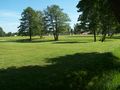
View of the field with the geohash from the bus stop
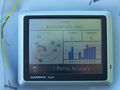
Image of my satnav showing the exact meetup coordinates (to five decimal places)

Obligatory stupid grin
View to the southeast from the geohash position
View to the southwest from the geohash position
View to the east from the geohash position: a portion of the original(?) concrete wall with barbed wire on top
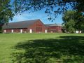
View to the northeast from the geohash position: brick factory
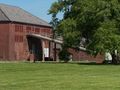
View to the northeast from the geohash: ramp of the brick factory


