Difference between revisions of "2010-06-10 50 14"
From Geohashing
imported>Emu (Update after the expedition) |
imported>Emu m (Categorized) |
||
| Line 26: | Line 26: | ||
Image:2010-06-10-50-14-HPIM3377.JPG | A huge tree in the village center of Byšičky, half a kilometer from the hash | Image:2010-06-10-50-14-HPIM3377.JPG | A huge tree in the village center of Byšičky, half a kilometer from the hash | ||
</gallery> | </gallery> | ||
| + | |||
| + | [[Category:Expeditions]] | ||
| + | [[Category:Expeditions with photos]] | ||
| + | [[Category:Coordinates reached]] | ||
Revision as of 21:56, 10 June 2010
| Thu 10 Jun 2010 in Prague: 50.1830694, 14.7989760 geohashing.info google osm bing/os kml crox |
Location
The hash was in a forest near village Byšičky, about two kilometers off the Labe bank. It was easily reachable on the bike way no. 24.
Participants
- Emu
- Filip
Expedition
We both travelled by bikes. Unfortunately we got to the location about fourty minutes past four p.m. If there was anybody else hashing, that's a shame.
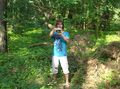
Emu holding a GPS. On its display it clearly shows we have reached the point.
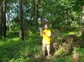
There is just no doubt about it, we are here.
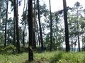
Our bicycles. If the resolution was just a bit better you could see loads of mosquitos all around.
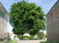
A huge tree in the village center of Byšičky, half a kilometer from the hash


