Difference between revisions of "2010-06-18 51 12"
From Geohashing
imported>Jiml m (Adjust Result codes - sounds like it was successful) |
imported>FippeBot m (Location) |
||
| (One intermediate revision by one other user not shown) | |||
| Line 1: | Line 1: | ||
| − | |||
| − | |||
| − | |||
| − | |||
| − | |||
| − | |||
{{meetup graticule | {{meetup graticule | ||
| lat=51 | | lat=51 | ||
| Line 11: | Line 5: | ||
}} | }} | ||
| − | + | ||
__NOTOC__ | __NOTOC__ | ||
== Location == | == Location == | ||
| − | |||
Near Leipzig | Near Leipzig | ||
| Line 21: | Line 14: | ||
== Plans == | == Plans == | ||
| − | |||
Unknown | Unknown | ||
== Expedition == | == Expedition == | ||
| − | |||
Apparently, it turned out well: The GPS coords on the | Apparently, it turned out well: The GPS coords on the | ||
GeoHashing Android App suggest the coords were reached. | GeoHashing Android App suggest the coords were reached. | ||
| − | |||
| − | |||
| − | |||
| − | |||
== Photos == | == Photos == | ||
| Line 43: | Line 30: | ||
== Achievements == | == Achievements == | ||
{{#vardefine:ribbonwidth|800px}} | {{#vardefine:ribbonwidth|800px}} | ||
| − | |||
| − | + | {{Land geohash | |
| − | + | | latitude=51 | |
| − | + | | longitude=12 | |
| − | [[ | + | | date=2010-06-18 |
| + | |name = [[User:Seidler|Seidler]] | ||
| + | }} | ||
[[Category:Expeditions]] | [[Category:Expeditions]] | ||
| Line 54: | Line 42: | ||
[[Category:Expeditions with photos]] | [[Category:Expeditions with photos]] | ||
[[Category:Coordinates reached]] | [[Category:Coordinates reached]] | ||
| + | {{location|DE|SN|L|city=true}} | ||
Latest revision as of 02:27, 9 August 2019
| Fri 18 Jun 2010 in 51,12: 51.3683658, 12.3235789 geohashing.info google osm bing/os kml crox |
Location
Near Leipzig
Participants
- Seidler and his wife
Plans
Unknown
Expedition
Apparently, it turned out well: The GPS coords on the GeoHashing Android App suggest the coords were reached.
Photos
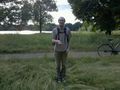
This is me, pointing to my first geohash... @51.3683,12.3236

Achievements
Seidler earned the Land geohash achievement
|