Difference between revisions of "2010-06-30 47 9"
imported>Ekorren (Been there. Consecutive geohash #6 :)) |
imported>Ekorren (Gallery up, report will follow.) |
||
| Line 21: | Line 21: | ||
== Gallery == | == Gallery == | ||
<gallery> | <gallery> | ||
| + | File:2010-06-30_47_9_Sauldorf.jpg|Sauldorf - the hike starts here | ||
| + | File:2010-06-30_47_9_Ortsschild.jpg|Out of the village. 3 km to Roth sounds a lot easier than the actual way was... | ||
| + | File:2010-06-30_47_9_Flora_1.jpg|Random impressions | ||
| + | File:2010-06-30_47_9_Sauldorf_2.jpg | ||
| + | File:2010-06-30_47_9_Track.jpg|Into the forest | ||
| + | File:2010-06-30_47_9_30m.jpg|30m to go | ||
| + | File:2010-06-30_47_9_Hashpoint.jpg|The hashpoint | ||
| + | File:2010-06-30_47_9_GPS.jpg|Coordinates reached | ||
| + | File:2010-06-30_47_9_Flora_2.jpg | ||
| + | File:2010-06-30_47_9_Roth.jpg|Hamlet of Roth. View from a bus stop that's not actually a bus stop because there are no buses stopping there. | ||
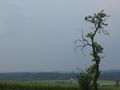
| + | File:2010-06-30_47_9_Tree.jpg | ||
| + | File:2010-06-30_47_9_Deer.jpg|It was MUCH closer when it started running, but it took me some time to get the camera ready | ||
| + | File:2010-06-30_47_9_BfSentenhart.jpg|Station of Sentenhart | ||
| + | File:2010-06-30_47_9_Bus.jpg|This bus won't take me anywhere | ||
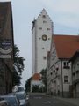
| + | File:2010-06-30_47_9_Pfullendorf_1.jpg|At Pfullendorf | ||
| + | File:2010-06-30_47_9_Pfullendorf_2.jpg | ||
</gallery> | </gallery> | ||
Revision as of 13:18, 2 July 2010
| Wed 30 Jun 2010 in 47,9: 47.9301497, 9.1002816 geohashing.info google osm bing/os kml crox |
Location
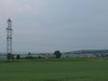
In a forest about 2 km from Sauldorf. This is the middle of nowhere.
Participants
Expedition
Reaching such places by bus is challenging for low service frequencies and missing networking between the few buses which actually go mostly for taking children to school and back. However, it's not impossible.
Going to write a report later.
Gallery

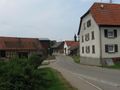
Sauldorf - the hike starts here

Out of the village. 3 km to Roth sounds a lot easier than the actual way was...

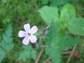
Random impressions

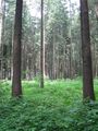
Into the forest

30m to go
The hashpoint

Coordinates reached
Hamlet of Roth. View from a bus stop that's not actually a bus stop because there are no buses stopping there.
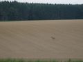
It was MUCH closer when it started running, but it took me some time to get the camera ready
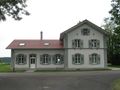
Station of Sentenhart

This bus won't take me anywhere

At Pfullendorf


Achievements
- Consecutive geohash #6