Difference between revisions of "2010-07-02 -43 147"
From Geohashing
imported>Alh (Created page with '{{subst:Expedition |lat = -43 |lon = 147 |date = 2010-07-02 }}') |
imported>Alh |
||
| Line 1: | Line 1: | ||
| − | |||
<!-- If you did not specify these parameters in the template, please substitute appropriate things for IMAGE, LAT, LON, and DATE (YYYY-MM-DD format) | <!-- If you did not specify these parameters in the template, please substitute appropriate things for IMAGE, LAT, LON, and DATE (YYYY-MM-DD format) | ||
| − | |||
| − | |||
And DON'T FORGET to add your expedition and the best photo you took to the gallery on the Main Page! We'd love to read your report, but that means we first have to discover it! | And DON'T FORGET to add your expedition and the best photo you took to the gallery on the Main Page! We'd love to read your report, but that means we first have to discover it! | ||
| Line 10: | Line 7: | ||
| lon=147 | | lon=147 | ||
| date=2010-07-02 | | date=2010-07-02 | ||
| + | | graticule_name=Huonville | ||
| + | | graticule_link=Huonville, Australia | ||
}} | }} | ||
| − | |||
__NOTOC__ | __NOTOC__ | ||
== Location == | == Location == | ||
| − | + | Off Tinderbox Road between Howden and Tinderbox | |
== Participants == | == Participants == | ||
| − | + | [[User:Alh|Alan]] | |
== Plans == | == Plans == | ||
| − | + | Plan was to drive there and have a look to see if it was accessible, Google maps showed it to be in an area of light bush, but possibly private property. | |
== Expedition == | == Expedition == | ||
| − | + | Drive there was uneventful. Off Tinderbox Road was a small turning circle with several driveways and driveway stubs for vacant blocks. Several no trespassing signs, but also several for sale signs, including the vacant block the hashpoint appeared to be on. A quick phone call and permission to enter was ''enthusiastically'' granted, before I even had a chance to say why I was there. A walk up a steepish hill through light bush got me to the hashpoint. | |
| − | == | + | == Technical issues == |
| − | + | * My cheap GPS nav unit doesn't really work very well for geohashing, coordinates don't update unless you move a significant distance, or power cycle. Even after power cycling while stationary the resulting coordinates are somewhat inconsistent. | |
| + | * Trying to the the ''standard proof'' picture is, well, trying. Backlit LCD from the nav unit, reflective LCD for the watch, plus me. | ||
== Photos == | == Photos == | ||
| − | |||
| − | |||
| − | |||
<gallery perrow="5"> | <gallery perrow="5"> | ||
| + | Image:2010-07-02_-43_147_Proof.jpg | Proof | ||
| + | Image:2010-07-02_-43_147_Location.jpg | What it looks like | ||
</gallery> | </gallery> | ||
== Achievements == | == Achievements == | ||
{{#vardefine:ribbonwidth|800px}} | {{#vardefine:ribbonwidth|800px}} | ||
| − | + | {{Ambassador geohash | |
| + | | latitude = -43 | ||
| + | | longitude = 147 | ||
| + | | date = 2010-07-02 | ||
| + | | name = Alh | ||
| + | }} | ||
| + | {{Virgin graticule | ||
| + | | latitude = -43 | ||
| + | | longitude = 147 | ||
| + | | date = 2010-07-02 | ||
| + | | name = Alh | ||
| + | }} | ||
| − | |||
| − | |||
| − | |||
| − | |||
| − | |||
| − | |||
| − | |||
| − | |||
| − | |||
[[Category:Expeditions]] | [[Category:Expeditions]] | ||
| − | |||
[[Category:Expeditions with photos]] | [[Category:Expeditions with photos]] | ||
| − | |||
| − | |||
| − | |||
| − | |||
| − | |||
[[Category:Coordinates reached]] | [[Category:Coordinates reached]] | ||
| − | |||
| − | |||
| − | |||
| − | |||
| − | |||
| − | |||
| − | |||
| − | |||
| − | |||
| − | |||
Revision as of 11:08, 2 July 2010
| Fri 2 Jul 2010 in Huonville: -43.0283449, 147.3162712 geohashing.info google osm bing/os kml crox |
Location
Off Tinderbox Road between Howden and Tinderbox
Participants
Plans
Plan was to drive there and have a look to see if it was accessible, Google maps showed it to be in an area of light bush, but possibly private property.
Expedition
Drive there was uneventful. Off Tinderbox Road was a small turning circle with several driveways and driveway stubs for vacant blocks. Several no trespassing signs, but also several for sale signs, including the vacant block the hashpoint appeared to be on. A quick phone call and permission to enter was enthusiastically granted, before I even had a chance to say why I was there. A walk up a steepish hill through light bush got me to the hashpoint.
Technical issues
- My cheap GPS nav unit doesn't really work very well for geohashing, coordinates don't update unless you move a significant distance, or power cycle. Even after power cycling while stationary the resulting coordinates are somewhat inconsistent.
- Trying to the the standard proof picture is, well, trying. Backlit LCD from the nav unit, reflective LCD for the watch, plus me.
Photos
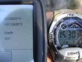
Proof

What it looks like


Achievements
Alh earned the Ambassador achievement
|