Difference between revisions of "2010-07-07 43 -88"
imported>Bassoon (Created page with '{{subst:Expedition |lat = 43 |lon = -88 |date = 2010-07-07 }}') |
imported>Bassoon |
||
| Line 1: | Line 1: | ||
| − | |||
| − | |||
| − | |||
| − | |||
| − | |||
| − | |||
| − | |||
{{meetup graticule | {{meetup graticule | ||
| lat=43 | | lat=43 | ||
| Line 12: | Line 5: | ||
}} | }} | ||
| − | |||
| − | |||
== Location == | == Location == | ||
| − | + | Glacial Blue Hills Recreation Area just outside of West Bend, Wisconsin. | |
== Participants == | == Participants == | ||
| − | + | *[[User:Bassoon|Warren]] | |
| + | *[[User:Dedehawk|Deanna]] | ||
| + | *[[User:Kuderererer|Jon]] | ||
== Plans == | == Plans == | ||
| − | + | Head out to the park in our formal attire, quickly make our way through the forest, and find the hash, then leave. | |
== Expedition == | == Expedition == | ||
| − | + | We thought it would be easy. Oh, yes, it would be simple. Just put on our formals and drive out to West Bend. When we almost got there, I noticed that my phone said that we were in a flash flood warning area...if only we had noticed such obvious attempts at foreshadowing. When we arrived at the park, we stepped outside to find it hot and humid. Really hot and really humid, especially in formal attire. Dedehawk quickly learned that there were bugs. Lots and lots of bugs. | |
| − | + | Bassoon strode up the first steep trail we found (pictured below) to survey. When he arrived at the top, it was a shock: instead of just being a hill, with the crest at the top of the trail, it seemed more like a plateau, spreading out in all directions, with copious amounts of trees and dense underbrush spread around to endanger our well-being. | |
| − | + | ||
| + | Bassoon came back down the hill and the three of us set off down the ATV path again. We heard the first sounds of distant thunder. It wasn't raining yet, though! The day could still be saved. We came to the lake pictured in the satellite photos. First, we took one side, but when we found that the underbrush and trees grew denser, we'd have to take the other instead, even though the original side was less steep. On the way past the lake, it started to rain. Just a little drizzle. | ||
| + | |||
| + | The trail past the lake stopped, but we didn't. The closer we got to the geohash, the more it started raining. The thunder got louder, stronger, and closer. It seemed as though we were getting the brunt of the storm in that tiny park. The terrain kept getting steeper and steeper, and it quickly seemed as though it would become a mudslide if the rain kept up. We kept pushing north, trying to get the coordinates to match up. But we finally reached a ravine filled with green plant life that was impassable. The storm was getting stronger, the rain was a downpour now, and the thunder was shaking everything. It was a miracle we weren't struck by lighting. | ||
| + | |||
| + | Getting back was a little more interesting than getting there. Everything was slippery. You could see where the streams of water were slowly eroding away the hills, nature's best effort to grind up new gravel. We finally reached the trail by the lake again. It was still pouring, and the thunder was still getting louder. When we reached the ATV tracks, we huddled together in the endless torrent of water. All of our formal clothes were completely soaked. As we walked back into the gravel parking lot, we saw that it was completely flooded, with muddy runoff draining into the forest. | ||
| + | |||
| + | When we reached the van, it was a hectic scramble to assemble all of the damageable electronics in a dry seat where they could dry themselves off. The heat was turned on full blast, which was kinda odd, considering it was the summer. We opened the back of the van to assemble for our obligatory group photo, seen below. We were completely soaked. Kuderererer and Bassoon removed their suits and left them to dry in back. Socks were rung out and shoes were taken off. Overall, it was a very wet adventure. | ||
| + | |||
| + | Although we didn't reach the hash, it was a lot of fun to try to, although it didn't feel like it at the time. The most important things that we learned today were to always check the radar before you go geohashing, and to heed the warnings your phone tells you before heading out into the wilderness. | ||
== Photos == | == Photos == | ||
| − | |||
| − | |||
| − | |||
<gallery perrow="5"> | <gallery perrow="5"> | ||
| + | Image:2010-07-07_43_-88_hopeful-beginnings.png | At this point in the trip, everyone is happy and hopeful. It seems to be a good day. | ||
| + | Image:2010-07-07_43_-88_steep-trail.png | We should have turned back here. At least it wasn't raining. | ||
| + | Image:2010-07-07_43_-88 decisions.png | We try to figure out which path will get us to the hash. | ||
| + | Image:2010-07-07_43_-88_sooooo-close.png | We were so close! Darn you, Mother Nature! | ||
| + | Image:2010-07-07 43_-88_escape.png | We escape from the storming park, trying to get away as fast as possible in wet formal attire. | ||
| + | Image:2010-07-07_43_-88_drowned-rat-plox.png | Maybe we got close enough to get an honorary drowned rat! Maybe? Please? We were in our formal wear! | ||
| + | Image:2010-07-07_43_-88_raptor-attack.png | Deanna got attacked by raptors at some point, but she got away. | ||
</gallery> | </gallery> | ||
== Achievements == | == Achievements == | ||
{{#vardefine:ribbonwidth|800px}} | {{#vardefine:ribbonwidth|800px}} | ||
| − | + | {{Formal attire | |
| − | + | | latitude = 43 | |
| − | + | | longitude = -88 | |
| − | + | | date = 2010-07-07 | |
| − | + | | name = Bassoon, Dedehawk, and Kuderererer | |
| − | + | | image = image name (optional) | |
| − | + | | honor = true | |
| − | + | }} | |
| − | + | {{Velociraptor geohash | |
| − | + | | latitude = 43 | |
| − | + | | longitude = -88 | |
| + | | date = 2010-07-07 | ||
| + | | name = Dedehawk | ||
| + | | image = image name (optional) | ||
| + | }} | ||
| + | {{mnb geohash | ||
| + | | latitude = 43 | ||
| + | | longitude = -88 | ||
| + | | date = 2010-07-07 | ||
| + | | name = Bassoon, Dedehawk, and Kuderererer | ||
| + | | image = image name (optional) | ||
| + | }} | ||
| + | {{Radio Yerevan | ||
| + | | achievement =[[Drowned Rat Geohash]] | ||
| + | | detail = we didn't actually reach the coordinates. We were .001 degrees south. | ||
| + | | date = 2010-07-07 | ||
| + | | latitude = 43 | ||
| + | | longitude = -88 | ||
| + | | user = Bassoon, Dedehawk, and Kuderererer | ||
| + | | image = | ||
| + | }} | ||
| − | |||
[[Category:Expeditions]] | [[Category:Expeditions]] | ||
| − | |||
[[Category:Expeditions with photos]] | [[Category:Expeditions with photos]] | ||
| − | |||
| − | |||
| − | |||
| − | |||
| − | |||
| − | |||
| − | |||
| − | |||
[[Category:Coordinates not reached]] | [[Category:Coordinates not reached]] | ||
| − | |||
[[Category:Not reached - Mother Nature]] | [[Category:Not reached - Mother Nature]] | ||
| − | |||
| − | |||
| − | |||
| − | |||
Revision as of 22:32, 7 July 2010
| Wed 7 Jul 2010 in 43,-88: 43.4489887, -88.2133258 geohashing.info google osm bing/os kml crox |
Location
Glacial Blue Hills Recreation Area just outside of West Bend, Wisconsin.
Participants
Plans
Head out to the park in our formal attire, quickly make our way through the forest, and find the hash, then leave.
Expedition
We thought it would be easy. Oh, yes, it would be simple. Just put on our formals and drive out to West Bend. When we almost got there, I noticed that my phone said that we were in a flash flood warning area...if only we had noticed such obvious attempts at foreshadowing. When we arrived at the park, we stepped outside to find it hot and humid. Really hot and really humid, especially in formal attire. Dedehawk quickly learned that there were bugs. Lots and lots of bugs.
Bassoon strode up the first steep trail we found (pictured below) to survey. When he arrived at the top, it was a shock: instead of just being a hill, with the crest at the top of the trail, it seemed more like a plateau, spreading out in all directions, with copious amounts of trees and dense underbrush spread around to endanger our well-being.
Bassoon came back down the hill and the three of us set off down the ATV path again. We heard the first sounds of distant thunder. It wasn't raining yet, though! The day could still be saved. We came to the lake pictured in the satellite photos. First, we took one side, but when we found that the underbrush and trees grew denser, we'd have to take the other instead, even though the original side was less steep. On the way past the lake, it started to rain. Just a little drizzle.
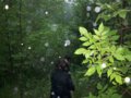
The trail past the lake stopped, but we didn't. The closer we got to the geohash, the more it started raining. The thunder got louder, stronger, and closer. It seemed as though we were getting the brunt of the storm in that tiny park. The terrain kept getting steeper and steeper, and it quickly seemed as though it would become a mudslide if the rain kept up. We kept pushing north, trying to get the coordinates to match up. But we finally reached a ravine filled with green plant life that was impassable. The storm was getting stronger, the rain was a downpour now, and the thunder was shaking everything. It was a miracle we weren't struck by lighting.
Getting back was a little more interesting than getting there. Everything was slippery. You could see where the streams of water were slowly eroding away the hills, nature's best effort to grind up new gravel. We finally reached the trail by the lake again. It was still pouring, and the thunder was still getting louder. When we reached the ATV tracks, we huddled together in the endless torrent of water. All of our formal clothes were completely soaked. As we walked back into the gravel parking lot, we saw that it was completely flooded, with muddy runoff draining into the forest.
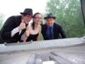
When we reached the van, it was a hectic scramble to assemble all of the damageable electronics in a dry seat where they could dry themselves off. The heat was turned on full blast, which was kinda odd, considering it was the summer. We opened the back of the van to assemble for our obligatory group photo, seen below. We were completely soaked. Kuderererer and Bassoon removed their suits and left them to dry in back. Socks were rung out and shoes were taken off. Overall, it was a very wet adventure.
Although we didn't reach the hash, it was a lot of fun to try to, although it didn't feel like it at the time. The most important things that we learned today were to always check the radar before you go geohashing, and to heed the warnings your phone tells you before heading out into the wilderness.
Photos

At this point in the trip, everyone is happy and hopeful. It seems to be a good day.
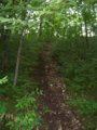
We should have turned back here. At least it wasn't raining.

We try to figure out which path will get us to the hash.

We were so close! Darn you, Mother Nature!
We escape from the storming park, trying to get away as fast as possible in wet formal attire.
Maybe we got close enough to get an honorary drowned rat! Maybe? Please? We were in our formal wear!

Deanna got attacked by raptors at some point, but she got away.


Achievements
Bassoon, Dedehawk, and Kuderererer earned the Formal attire achievement
|
Dedehawk earned the Velociraptor Geohash Achievement
|
Is it true that Bassoon, Dedehawk, and Kuderererer earned the Drowned Rat Geohash?
|