Difference between revisions of "2010-07-10 33 -117"
From Geohashing
imported>Marine Mustang (→Expedition) |
imported>Marine Mustang (→Achievements) |
||
| Line 42: | Line 42: | ||
{{#vardefine:ribbonwidth|800px}} | {{#vardefine:ribbonwidth|800px}} | ||
<!-- Add any achievement ribbons you earned below, or remove this section --> | <!-- Add any achievement ribbons you earned below, or remove this section --> | ||
| − | + | {{land geohash | |
| + | | latitude = 33 | ||
| + | | longitude = -117 | ||
| + | | date = 2010-07-10 | ||
| + | | name = Marine_Mustang | ||
| + | | image = IMG_0031.jpg | ||
| + | }} | ||
<!-- =============== USEFUL CATEGORIES FOLLOW ================ | <!-- =============== USEFUL CATEGORIES FOLLOW ================ | ||
Revision as of 00:59, 11 July 2010
| Sat 10 Jul 2010 in 33,-117: 33.6311590, -117.7338689 geohashing.info google osm bing/os kml crox |
Location
Near corner of Lake Forest Drive and Scientific Way.
Participants
Jason (Marine_Mustang)
Plans
Expedition
Drove north on I-5 from Oceanside, left on Lake Forest exit, right on Scientific Way. Had some Del Taco on the way.
Well, I'm here. No one else except someone who stopped across the street in a white car, but didn't get out. Don't be so unfriendly next time!
Tracklog
Photos
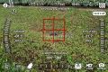
Screenshot from my iPhone using Theodolite Pro

My daughter at the hash location, entertaining herself with our iPad
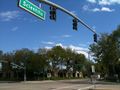
Nearest cross-street


Achievements
Marine_Mustang earned the Land geohash achievement
|