Difference between revisions of "2010-07-25 52 1"
imported>MagicIan (→Expedition) |
imported>FippeBot m (Location) |
||
| (3 intermediate revisions by one other user not shown) | |||
| Line 7: | Line 7: | ||
| lon=1 | | lon=1 | ||
| date=2010-07-25 | | date=2010-07-25 | ||
| − | | graticule_name= | + | | graticule_name=Norwich |
| − | | graticule_link= | + | | graticule_link=Norwich, United Kingdom}} |
== Participants == | == Participants == | ||
| Line 36: | Line 36: | ||
<gallery perrow="4"> | <gallery perrow="4"> | ||
| − | Image: | + | Image:100725_field.JPG|Photo taken on the way to the hashpoint for Sunday 2010-07-25, 52.518213° 1.641496° (Norwich, United Kingdom) |
| − | </gallery> | + | Image:100725_me.JPG|Photo of [[User:MagicIan|MagicIan]] at the hashpoint for Sunday 2010-07-25, 52.518213° 1.641496° (Norwich, United Kingdom) |
| + | Image:100725_x.JPG|Photo of marker (the start of "XKCD" before [[User:MagicIan|MagicIan]] got scared of the bulls and ran away) from the hashpoint for Sunday 2010-07-25, 52.518213° 1.641496° (Norwich, United Kingdom)</gallery> | ||
| Line 67: | Line 68: | ||
[[Category:Expeditions with photos]][[Category:Expeditions]][[Category:Coordinates reached]] | [[Category:Expeditions with photos]][[Category:Expeditions]][[Category:Coordinates reached]] | ||
| + | {{location|GB|ENG|SFK}} | ||
Latest revision as of 02:58, 9 August 2019
Location
In a field near Somerleyton
| Sun 25 Jul 2010 in Norwich: 52.5182129, 1.6414956 geohashing.info google osm bing/os kml crox |
Participants
Expedition
MagicIan used this has as an excuse to go for a 40 mile cycle!
It was a nice day so he set off and quickly covered the 10 miles to Loddon on roads he knew. The next 10 miles to the hashpoint were slighly trickier due to the need for navigation, and the fact the roads were busier and more exposed. He got within half a mile of the hashpoint by bike, before locking it up and continuing on foot. There was a small footpath towards Smock Mill (old windmill) which he took half way, before taking a left through the fields along the edge of the wood. All was going well until he reached the field containing the hashpoint. At no point when pulling on his bright red cycling top had he considered the field containing the hashpoint might also contain bulls! (It was only since his return that he discovered bulls are colourblind and only feel threatened by fast movements). Anyway, despite it not being a particularly big field, the bulls were over the opposite side to the hashpoint itself so he walked over, took a quick photo and buggered off! This was one of the rare occasions were he didn't stop to lay a marker!
Something else that he hadn't realised until it was too late was that the wind was behind him on the way there, which meant that it was against him on the return journey. The first half to Loddon was on very flat land with no shelter whatsoever, and the latter half was full of lots of little hills. Whereas his average speed on the way back had been a nice 17mph (27kph), on the way back this had dropped to 13mph (21kph) - it was a real slog!
Achievements
MagicIan earned the Bicycle geohash achievement
|
Photos
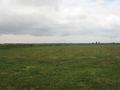
Photo taken on the way to the hashpoint for Sunday 2010-07-25, 52.518213° 1.641496° (Norwich, United Kingdom)
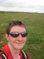
Photo of MagicIan at the hashpoint for Sunday 2010-07-25, 52.518213° 1.641496° (Norwich, United Kingdom)
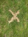
Photo of marker (the start of "XKCD" before MagicIan got scared of the bulls and ran away) from the hashpoint for Sunday 2010-07-25, 52.518213° 1.641496° (Norwich, United Kingdom)


