Difference between revisions of "2010-07-30 49 21"
imported>AlfonZ (achievement) |
imported>AlfonZ (achievement) |
||
| Line 44: | Line 44: | ||
<!-- Add any achievement ribbons you earned below, or remove this section --> | <!-- Add any achievement ribbons you earned below, or remove this section --> | ||
{{land geohash | {{land geohash | ||
| + | | latitude = 49 | ||
| + | | longitude = 21 | ||
| + | | date = 2010-07-30 | ||
| + | | name = [[User:AlfonZ|AlfonZ]] | ||
| + | }} | ||
| + | {{Virgin graticule | ||
| latitude = 49 | | latitude = 49 | ||
| longitude = 21 | | longitude = 21 | ||
Revision as of 15:42, 31 July 2010

| Fri 30 Jul 2010 in 49,21: 49.0236281, 21.1898671 geohashing.info google osm bing/os kml crox |
Location
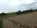
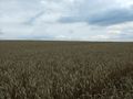
On a wheat field between Malý Šariš village and Veľký Šariš town.
Participants
Expedition
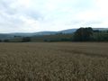
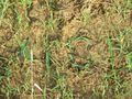
According to map, there is a road about 50m from the hashpoint. Getting there (by my motorized vehicle) was the easy part. The wheat on the field was ripe. Fortunately, a track led in the right direction. The past week's rains made the ground slightly muddy, forcing me to move slowly. The track missed the hashpoint by mere 1m, so I paced up and down to find the nearest point. Happily, I took pictures and started moving back. Two cyclists rode by on the nearby road, glanced at me, and ignored me. Obviously they were no geohashers. At the edge of the field I made an improvised mark from grass. I better bring some chalk next time.
Photos
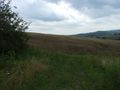
The wheat field the hashpoint is on
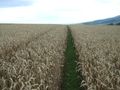
Tracks leading to the hashpoint
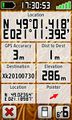
Coordinates reached
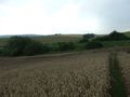
North view from the hashpoint
East view from the hashpoint
South view from the hashpoint
West view from the hashpoint
Improvised mark from grass at the edge of the field


Achievements
AlfonZ earned the Land geohash achievement
|