Difference between revisions of "2010-08-16 50 -113"
From Geohashing
imported>Air384 (Created page.) |
imported>Air384 (added photos) |
||
| Line 15: | Line 15: | ||
==Photos== | ==Photos== | ||
| − | ' | + | |
| + | <gallery perrow="5"> | ||
| + | Image:2010 08 16 50 -113 proof.JPG|GPS proof! | ||
| + | Image:2010 08 16 50 -113 view from hashpoint.JPG|View from the hashpoint. | ||
| + | Image:2010 08 16 50 -113 stupid grin1.JPG|[[User:air384|air384]] attempts a Stupid Grin(TM). | ||
| + | Image:2010 08 16 50 -113 stupid grin2.JPG|Perhaps this grin is less stupid? | ||
| + | Image:2010 08 16 50 -113 hashpoint panoramic.JPG|Panoramic! | ||
| + | Image:2010 08 16 50 -113 llamas.JPG|Llamas! Didn't pet them though... | ||
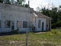
| + | Image:2010 08 16 50 -113 Stavley sign.JPG|The nearest town. | ||
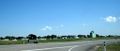
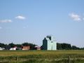
| + | Image:2010 08 16 50 -113 grain elevator.JPG|Quintessential small-town Alberta: grain elevators! | ||
| + | |||
| + | </gallery> | ||
==Achievements== | ==Achievements== | ||
Revision as of 02:03, 17 August 2010
| Mon 16 Aug 2010 in 50,-113: 50.1611331, -113.6865967 geohashing.info google osm bing/os kml crox |
Location
Somewhere along the side of Range Road 280 in southern Alberta, in the SE Calgary graticule.
Participants
Expedition
Details coming soon!
Photos
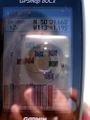
GPS proof!
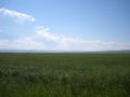
View from the hashpoint.

air384 attempts a Stupid Grin(TM).

Perhaps this grin is less stupid?

Panoramic!
Llamas! Didn't pet them though...
The nearest town.
Quintessential small-town Alberta: grain elevators!


