Difference between revisions of "2010-08-08 31 -110"
From Geohashing
imported>Wyle & RoadRunner (Created page with '{{meetup graticule | lat=31 | lon=-110 | date=2010-08-08 | graticule_name=Nogales | graticule_link=Nogales, Arizona}} == Location == East of Sahuarita, north of Madera Canyon …') |
imported>FippeBot m (Location) |
||
| Line 26: | Line 26: | ||
[[Category:Expeditions with photos]] | [[Category:Expeditions with photos]] | ||
[[Category:Coordinates reached]] | [[Category:Coordinates reached]] | ||
| + | {{location|US|AZ|PM}} | ||
Latest revision as of 03:10, 9 August 2019
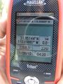
| Sun 8 Aug 2010 in Nogales: 31.8514438, -110.8988717 geohashing.info google osm bing/os kml crox |
Location
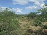
East of Sahuarita, north of Madera Canyon
Participants
- Wyle & RoadRunner w/o RoadRunner
- Jen (Wyle's daughter, the newbie)
Expeditions
Well, the newbie liked it so much yesterday, that she was ready to go again. Even *less* hiking this time ... and a Honda could have driven it (ongoing joke about RoadRunner's vehicle). Cows on the dirt road and one calf in particular that watched us approach and then pranced off. Literally hopping on her front legs. Reminded us of our chow-mix dog who often does the same thing. Found the spot, enjoyed the view, almost got stuck in a sandy wash doing a U-turn and headed out baja style (40-50 mph) on the dirt. Actually had to slow down to the speed limit when we hit pavement. LOL.
Nogales, Arizona
Nogales, Arizona

Nogales, Arizona


