Difference between revisions of "2010-08-22 60 22"
From Geohashing
imported>Team pson (→About) |
imported>FippeBot m (Location) |
||
| (4 intermediate revisions by one other user not shown) | |||
| Line 15: | Line 15: | ||
Decided to try reach our first geohash this beautiful Sunday, there was only private roads goin to the | Decided to try reach our first geohash this beautiful Sunday, there was only private roads goin to the | ||
shore so had to leave the car about 500 meters from the point and then jump over a ditch followed by some easier field terrain. | shore so had to leave the car about 500 meters from the point and then jump over a ditch followed by some easier field terrain. | ||
| − | + | The exact geohash point was abit out in the water from the shore | |
| − | so i wasnt really quite on top of it | + | so i wasnt really quite on top of it and i didnt feel for swimmin today, the final approach out to the shoreline and water consisted mostly of reed. Took one picture of the point, this was a |
| − | + | interesting trip to a new unfamiliar place not so far from home. | |
==Photos== | ==Photos== | ||
| Line 26: | Line 26: | ||
[[Category:Expeditions with photos]] | [[Category:Expeditions with photos]] | ||
[[Category:Expeditions]] | [[Category:Expeditions]] | ||
| − | [[Category:Coordinates reached]] | + | [[Category:Coordinates not reached]] |
| + | [[Category:Not reached - Mother Nature]] | ||
| + | {{location|FI|19}} | ||
Latest revision as of 03:25, 9 August 2019
| Sun 22 Aug 2010 in Turku: 60.3619455, 22.4124052 geohashing.info google osm bing/os kml crox |
About
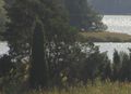
The location is at Island of Kirjala thats in Parainen/Pargas, Almost reached by team_pson.
The trip
Decided to try reach our first geohash this beautiful Sunday, there was only private roads goin to the shore so had to leave the car about 500 meters from the point and then jump over a ditch followed by some easier field terrain. The exact geohash point was abit out in the water from the shore so i wasnt really quite on top of it and i didnt feel for swimmin today, the final approach out to the shoreline and water consisted mostly of reed. Took one picture of the point, this was a interesting trip to a new unfamiliar place not so far from home.
Photos
The point
