Difference between revisions of "2010-08-19 54 10"
From Geohashing
imported>Dawidi (quick writeup and pictures for an arguably not very interesting expedition) |
imported>Jiml m (Adjust result categories; Reformatting) |
||
| Line 4: | Line 4: | ||
| date=2010-08-19 | | date=2010-08-19 | ||
}} | }} | ||
| + | |||
| + | == Location == | ||
In a (not yet harvested) field north of Bad Malente-Gremsmühlen. | In a (not yet harvested) field north of Bad Malente-Gremsmühlen. | ||
| − | == [[User:dawidi|dawidi]] == | + | == Participants == |
| − | I had spent the afternoon visiting relatives near Preetz, and left them around 17:30. With a good tailwind helping me maintain a good speed without much effort, I cycled east to this geohash, found it inaccessible, chatted a bit with a hunter, and then coasted on to the train station in Bad Malente-Gremsmühlen. The train I meant to get on to bring me back to Kiel was canceled, so I spent half an hour getting a spring roll from a nearby | + | * [[User:dawidi|dawidi]] |
| + | |||
| + | == [[User:dawidi|dawidi]]'s Expedition == | ||
| + | I had spent the afternoon visiting relatives near Preetz, and left them around 17:30. With a good tailwind helping me maintain a good speed without much effort, I cycled east to this geohash, found it inaccessible, chatted a bit with a hunter, and then coasted on to the train station in Bad Malente-Gremsmühlen. The train I meant to get on to bring me back to Kiel was canceled, so I spent half an hour getting a spring roll from a nearby Chinese restaurant and eating it before the next train arrived. | ||
| − | <gallery> | + | == Photos == |
| + | <gallery perrow="3"> | ||
File:2010-08-19 54 10 old windmill.jpg|Old windmill in Grebin. | File:2010-08-19 54 10 old windmill.jpg|Old windmill in Grebin. | ||
File:2010-08-19 54 10 windwidi.jpg|New windmill, and dawidi, near the geohash. | File:2010-08-19 54 10 windwidi.jpg|New windmill, and dawidi, near the geohash. | ||
| Line 16: | Line 22: | ||
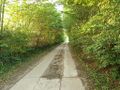
File:2010-08-19 54 10 track.jpg|Field track west of the geohash. | File:2010-08-19 54 10 track.jpg|Field track west of the geohash. | ||
</gallery> | </gallery> | ||
| + | |||
[[File:2010-08-19 54 10 hashpano.jpg|thumb|640px|none|Somewhat of a panorama, 280m north of the hashpoint]] | [[File:2010-08-19 54 10 hashpano.jpg|thumb|640px|none|Somewhat of a panorama, 280m north of the hashpoint]] | ||
| + | |||
[[Category:Expeditions]] | [[Category:Expeditions]] | ||
[[Category:Expeditions with photos]] | [[Category:Expeditions with photos]] | ||
[[Category:Coordinates not reached]] | [[Category:Coordinates not reached]] | ||
| − | [[Category: | + | [[Category:Not reached - No public access]] |
Revision as of 18:19, 11 October 2010
| Thu 19 Aug 2010 in 54,10: 54.2114245, 10.5190795 geohashing.info google osm bing/os kml crox |
Location
In a (not yet harvested) field north of Bad Malente-Gremsmühlen.
Participants
dawidi's Expedition
I had spent the afternoon visiting relatives near Preetz, and left them around 17:30. With a good tailwind helping me maintain a good speed without much effort, I cycled east to this geohash, found it inaccessible, chatted a bit with a hunter, and then coasted on to the train station in Bad Malente-Gremsmühlen. The train I meant to get on to bring me back to Kiel was canceled, so I spent half an hour getting a spring roll from a nearby Chinese restaurant and eating it before the next train arrived.
Photos
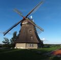
Old windmill in Grebin.
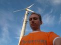
New windmill, and dawidi, near the geohash.
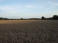
Not yet harvested, therefore inaccessible.
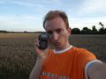
Coordinates not reached :(
Field track west of the geohash.


