Difference between revisions of "2010-09-01 -36 174"
imported>Jiml m (Fix typos) |
imported>Greenslime m (→Photos) |
||
| Line 37: | Line 37: | ||
Image:20100901_-36_174_Hash.JPG|This is Auckland, lucky this landed on land | Image:20100901_-36_174_Hash.JPG|This is Auckland, lucky this landed on land | ||
Image:20100901 -36 174 Bearing.JPG|Hoping for no fences, but hoping for golf balls | Image:20100901 -36 174 Bearing.JPG|Hoping for no fences, but hoping for golf balls | ||
| + | Image:2010-09-01 -36 174 Intersection.jpg|Intersection of tracks by hash point seen in satellite image | ||
| + | Image:2010-09-01 -36 174 Gully.jpg|No fences, but this gully instead | ||
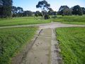
| + | Image:2010-09-01 -36 174 Hash Point.jpg|Hash point, could be anywhere.... | ||
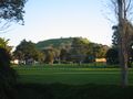
| + | Image:2010-09-01 -36 174 Mt Victoria.jpg|Proceeded to run from here up this big hill (Mt Victoria) | ||
| + | Image:2010-09-01 -36 174 Auckland at Sunset.jpg|This is Auckland. View from the top of Mt Vic | ||
</gallery> | </gallery> | ||
Revision as of 08:03, 1 September 2010
| Wed 1 Sep 2010 in -36,174: -36.8186082, 174.8009115 geohashing.info google osm bing/os kml crox |
Location
Golf course, Vauxhall, Devonport Peninsula, North Shore City, Auckland, New Zealand
Participants
Plans
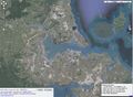
This hash isn't too far from my house. Will go home after work and pick up camera, compass and running gear (multi-task potential), and drive down to the golf course. Take a bearing of 270 degrees from the driveway of 32 Wairoa, and wander along this bearing until I reach the path shown in satellite image below.
Hoping there will be no fences to thwart this effort like on other occassions
Expedition
Tracklog
Photos
This is Auckland, lucky this landed on land
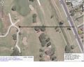
Hoping for no fences, but hoping for golf balls
Intersection of tracks by hash point seen in satellite image
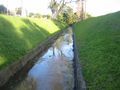
No fences, but this gully instead

Hash point, could be anywhere....
Proceeded to run from here up this big hill (Mt Victoria)
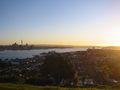
This is Auckland. View from the top of Mt Vic


Achievements